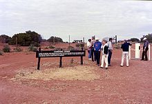

Pinaroo is a remote civil parish of Poole County in far north west New South Wales, located at 29°08′04″S 141°06′55″E.
Features
The parish is notable for being in the top north west corner of New South Wales and contains Cameron's Corner.
The geography of Pinaroo is mostly the flat, arid landscape of the Channel Country but includes Lake Pinaroo. The parish lies entirely within the Sturt National Park.
The Queensland-New South Wales border forms the northern boundary of the parish, which is marked by The Dingo Fence, and the western boundary is the border with South Australia.
The parish has a Köppen climate classification of BWh (Hot desert). The county is barely inhabited with a population density of less than 1 person per 150 km² and the landscape is a flat arid scrubland.
History
The parish is the traditional lands of the Wadigali, Wandruwandha and Malyangaba Aboriginal peoples.
Charles Sturt passed through the parish during 1845.
In 1861 the Burke and Wills expedition passed to the east, through what is now the Pindera Aboriginal Area, on the far side of Sturt National Park.
Gold was discovered nearby in the 1870s, and the miners were soon followed by pastoralists.
In 1880 Cameron Corner Survey Marker was established.
The Dingo Fence was completed in 1885.
Sturt National Park was established in 1972.
References
- "Poole County". Geographical Names Register (GNR) of NSW. Geographical Names Board of New South Wales.

- / Map of the County of Poole : Western Division, .
- Olive Downs campground.
- Sturt National Park, Outback NSW.
- Peel, M. C.; Finlayson, B. L.; McMahon, T. A. (2007). "Updated world map of the Köppen–Geiger climate classification". Hydrol. Earth Syst. Sci. 11: 1633–1644. doi:10.5194/hess-11-1633-2007. ISSN 1027-5606. (direct: Final Revised Paper)
- David R Horton (creator), Aboriginal Studies Press, AIATSIS, and Auslig/Sinclair, Knight, Merz, 1996.
- Aboriginal Heritage Corner Country History & Heritage Archived 1 March 2018 at the Wayback Machine.
- Sturt's Central Australian Expedition Archived 1 March 2018 at the Wayback Machine.
- The Burke and Wills Expedition Archived 1 March 2018 at the Wayback Machine.
- NSW National Parks and Wildlife service, Draft Plan of Management Sturt National Park, (2017) p 22.
- "Tibooburra". The Sydney Morning Herald. 1 January 2009.
This Far West geography article is a stub. You can help Misplaced Pages by expanding it. |