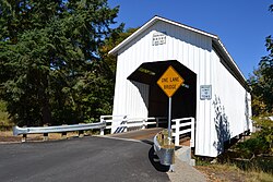
| Parvin Bridge | |
| U.S. National Register of Historic Places | |
 Parvin Bridge Parvin Bridge | |
  | |
| Nearest city | Dexter, Oregon |
|---|---|
| Coordinates | 43°53′59″N 122°49′17″W / 43.89972°N 122.82139°W / 43.89972; -122.82139 |
| Area | 0.1 acres (0.040 ha) |
| Built | 1921 |
| Built by | George W. Breeding |
| Architectural style | Howe truss |
| MPS | Oregon Covered Bridges TR |
| NRHP reference No. | 79003767 |
| Added to NRHP | November 29, 1979 |
The Parvin Bridge is a covered bridge located in Lane County, Oregon, U.S. near Dexter. It was built in 1921 as a single-lane 75-foot (23 m) bridge across Lost Creek, a tributary of the Middle Fork Willamette River.
The bridge was a replacement for a 66-foot (20 m) Howe truss design which failed a 1917 inspection by bridge inspector J. W. McArthur. He wrote, "An old bridge. Chords badly worm eaten. Downstream chord has been reinforced in middle by a timber bolted on. Wood is but little better than a powder from worm action. All signs indicate a new bridge in from 2 to 4 years."
George W. Breeding constructed the present bridge at the same site in 1921 for $3,617, equivalent to $61,800 today. It is also a Howe truss and includes a 62-foot (19 m) eastern approach and a 17-foot (5.2 m) western approach. Roadwork in the mid-1970s realigned the road to bypass the bridge, being accessible only to pedestrians afterwards. A dedication ceremony was held November 17, 1986, to reopen the renovated span to vehicle traffic with a 10-short-ton (9,100 kg) load limit.
The Parvin Bridge is listed on the National Register of Historic Places.
See also
- List of bridges on the National Register of Historic Places in Oregon
- List of Oregon covered bridges
- National Register of Historic Places listings in Lane County, Oregon
References
- "National Register Information System". National Register of Historic Places. National Park Service. July 9, 2010.
- ^ "Lost Creek (Parvin) Covered Bridge" (PDF). Oregon Department of Transportation. 19 December 2002. Retrieved 29 September 2011.
- 1634–1699: McCusker, J. J. (1997). How Much Is That in Real Money? A Historical Price Index for Use as a Deflator of Money Values in the Economy of the United States: Addenda et Corrigenda (PDF). American Antiquarian Society. 1700–1799: McCusker, J. J. (1992). How Much Is That in Real Money? A Historical Price Index for Use as a Deflator of Money Values in the Economy of the United States (PDF). American Antiquarian Society. 1800–present: Federal Reserve Bank of Minneapolis. "Consumer Price Index (estimate) 1800–". Retrieved February 29, 2024.
- "Oregon National Register List" (PDF). Oregon Parks and Recreation Department. June 6, 2011. p. 20. Retrieved July 17, 2011.
| U.S. National Register of Historic Places in Oregon | ||
|---|---|---|
| Lists by county |   | |
| Portland lists | ||
| Other lists | ||
- 1921 establishments in Oregon
- Covered bridges on the National Register of Historic Places in Oregon
- Covered bridges in Lane County, Oregon
- National Register of Historic Places in Lane County, Oregon
- Road bridges on the National Register of Historic Places in Oregon
- Wooden bridges in Oregon
- Howe truss bridges in the United States