| Pasar Minggu | |
|---|---|
| District | |
 Pasar Minggu Baru station Pasar Minggu Baru station | |
| Location in South Jakarta | |
| Country | Indonesia |
| Province | Jakarta |
| Administrative city | South Jakarta |
| Area | |
| • Total | 21.90 km (8.46 sq mi) |
| Elevation | 36 m (118 ft) |
| Postal code | 125XX |
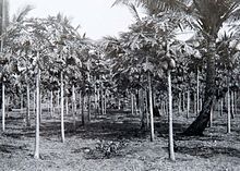
Pasar Minggu is a district (Indonesian: kecamatan) in the administrative city of South Jakarta, Indonesia. The area is known for its traditional Sunday market, famous for the fruit market. Historically, Pasar Minggu is a fruit cultivation area developed by the Dutch government during the colonial period. The central point of the cultivation area is the traditional market of Pasar Minggu, located in what is now the lower-division Pasar Minggu subdistrict. Teak forest could also be found in the Pasar Minggu district, notably around the Jati Padang (Javanese for "bright teak") subdistrict. Most of these areas have been converted into residential areas as Jakarta grows southward.
The boundary of Pasar Minggu is Kemang Selatan Road - Warung Jati Timur Road - Kalibata Timur Road to the north, Ciliwung River to the east, and Krukut River to the west.
The southern portion of Jakarta Outer Ring Road passed through Pasar Minggu district.
Subdistricts
The district of Pasar Minggu is divided into seven kelurahan or subdistricts:
| Name | Area code |
|---|---|
| Pejaten Barat | 12510 |
| Pejaten Timur | 12510 |
| Pasar Minggu | 12520 |
| Kebagusan | 12520 |
| Jati Padang | 12540 |
| Ragunan | 12550 |
| Cilandak Timur | 12560 |
History
The name Pasar Minggu derives from Pasar Minggu, a state-owned market located in the administrative village of the same name. The neighborhood of Pasar Minggu was – in the 17th-century – an ommelanden of Batavia located uphill. The land is located between the Ciliwung to the east and the stream of Mampang.
In the 18th-century, two parcels of land in what is now the district of Pasar Minggu were recorded as the property of Diogo Merendo and Simão Rodrigo who bought the land in mid 17th-century.
Pasar Minggu Market

Before 1920, market activity in the area was centered in Kampung Lio, closer to the west bank of the Ciliwung. The market opened every Sunday morning, hence the name Pasar Minggu, Malay for "Sunday Market". Pasar Minggu mainly consisted of bamboo-structured stalls. At this time, the market was also known for its gambling activities and a ronggeng performance known as Doger.
In 1920, the location of the market was shifted closer to the railway line. Chinese merchants began setting up their activity in Pasar Minggu, mainly on rice-selling.
In 1930, land to the west of Jalan Pasar Minggu (formerly the property of Dales, who took residence in Tanjung West) was opened by the colonial government to establish a more permanent building for the market. The first structure built for the market was a simple steel structure topped with a zinc roof. The new market sold a variety of daily necessities e.g. clothing, as well as fruits, mostly collected from the surrounding orchards. Pasar Minggu was also set to open every day. Despite this, Pasar Minggu was still busier on Sunday. In 1931, the road connecting Pasar Minggu with Manggarai was paved, giving more access for people to Pasar Minggu.
Following the expansion of the boundary of the city of Jakarta, the area of Pasar Minggu was planned as a residential area. The plan converts some of the existing orchards into residential.
The present Pasar Minggu building was inaugurated by the governor of Jakarta at that time Governor Tjokropranolo in 1984.
Landmarks

- Pasar Minggu market, bus terminal, and railway station.
- Ministry of Agriculture building complex
- Ragunan Zoo
- Republika building
See also
References
- "Kecamatan Pasar Minggu". Ensiklopedi Jakarta. Dinas Komunikasi, Informatika dan Kehumasan Pemprov DKI Jakarta. 2010. Retrieved January 14, 2017.
- Erna (October 19, 2009). "Kembalikan Pasar Minggu Jadi Pasar Buah" (in Indonesian). BeritaJakarta.com. Retrieved January 17, 2011.
- Unknown, early 18th-century.
- ^ S. Budhisantoso 1986, pp. 33–4. sfn error: no target: CITEREFS._Budhisantoso1986 (help)
- ^ Yandri Irsan 2008, pp. 62–5.
Cited works
- Kaart van Batavia, tusschen de rivier Groot Tsjiakon, de rivier Crocot en het spruytjie Tsiroa [Map of Batavia, between the Great River Tsjiakon, River Krukut and the Stream Tsiroa.] (Map). 50 rhijnlandsche roeden (in Dutch). Cartography by J.J. Bollee. anonymous. c. 1700s. Retrieved June 3, 2018.
- S. Budhisantoso; et al. (1986). Alat Penjaja Tradisional Daerah Khusus Ibukota Jakarta (in Indonesian). Jakarta: Direktorat Jenderal Kebudayaan.
- Yandri Irsan (2008). "Keberadaan Preman di Pasar Minggu dan Penanganan oleh Polsek Metro Pasar Minggu" (PDF). Jakarta: Universitas Indonesia. Retrieved June 4, 2018.
{{cite journal}}: Cite journal requires|journal=(help)
External links
- "Sejarah Nama-Nama Pasar di Jakarta" [History of Market Names in Jakarta]. Ensiklopedi Jakarta (in Indonesian). Dinas Komunikasi, Informatika dan Kehumasan Pemprov DKI Jakarta. May 5, 2010. Archived from the original on April 30, 2017. Retrieved June 4, 2018.
| Administrative areas of Jakarta | ||
|---|---|---|
| Administrative cities and regencies of Jakarta | ||
| Central Jakarta |  | |
| West Jakarta | ||
| South Jakarta | ||
| East Jakarta | ||
| North Jakarta | ||
| Thousand Islands | ||
| See also: List of districts of Jakarta | ||