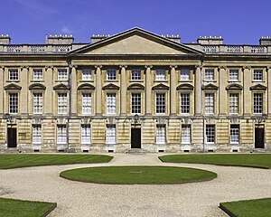
The Peckwater Quadrangle (known as "Peck" to students) is one of the quadrangles of Christ Church, Oxford, England. It is a Grade I listed building.
Christ Church Library is on the south side of the quad. To the southeast is Canterbury Quadrangle, with access to Oriel Square via Canterbury Gate.
Peckwater Quad is on the site of a medieval inn, which was run by the Peckwater family and given to St Frideswide's Priory in 1246.
The buildings on the north, east and west sides of the Quadrangle were designed by Henry Aldrich and built by William Townesend between 1706 and 1711. They constitute one of the earliest examples of English neo-Palladian architecture. The Library, on the south side, dates from later in the 18th century. First floor rooms in this quad have traditionally been particularly sought after by undergraduate members of the college due to their size, oak panelling and high ceilings. The largest examples of these rooms can be found in the corners of the building.
On 12 May 1894 and again on 20 February 1927, after dinner, Bullingdon Club members smashed almost all the glass of the lights and 468 windows in the quadrangle, along with the blinds and doors of the building.
Gallery
Panorama

See also
References
- Historic England. "Details from listed building database (1198828)". National Heritage List for England. Retrieved 9 July 2015.
- Wade, W. M.; William Baxter; R. Pearson; Law and Whittaker (1818). Walks in Oxford (2 ed.). Printed by W. Baxter for R. Pearson. p. 236. Retrieved 1 February 2009.
- Harris, John (1994). The Palladian Revival: Lord Burlington, His Villa and Garden at Chiswick. Yale University Press. p. 9. ISBN 9780300059830. Retrieved 25 June 2015.
- Curl, James (2002). Georgian Architecture. David & Charles. pp. 26–27. ISBN 9780715302279. Retrieved 25 June 2015.
- New York Times (13 May 1894). "Condensed Cablegrams" (PDF). The New York Times.
- Trevor Henry Aston (1984). The History of the University of Oxford. ISBN 9780199510177.
- J. G. Sinclair (2007). Portrait of Oxford. ISBN 9781406745856.
51°45′05″N 1°15′18″W / 51.7513°N 1.2550°W / 51.7513; -1.2550
This Oxfordshire location article is a stub. You can help Misplaced Pages by expanding it. |


