| Plaatjieskraal | |
|---|---|
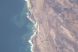
 View of Plaatjieskraal from space. View of Plaatjieskraal from space. | |
  | |
| Coordinates: 34°43′46″S 19°35′50″E / 34.72944°S 19.59722°E / -34.72944; 19.59722 | |
| Country | South Africa |
| Province | Western Cape |
| District | Overberg |
| Municipality | Overstrand |
| Established | 1980s |
| Abandoned | 2010 |
| Website | https://www.facebook.com/plaatjieskraalspookdorp |
Plaatjieskraal is a ghost town in the Western Cape province of South Africa located about 10 km southeast of Pearly Beach and 10 km southwest of Wolvengat.
The town was established in the 1980s, but was abandoned around 2010 and has since been taken over by sand dunes.
The town was built by the district municipality for people living in Elim and Bredasdorp. The town consists of 23 houses.
References
- "Exploring Plaatjieskraal Ghost Town". 2021-02-11. Retrieved 2024-07-04.
- "Plaatjieskraal Spookdorp". Jeep Club. Retrieved 2024-07-04.
- "Activities - Ghost Town Visit". Salted Fynbos Staying. Retrieved 2024-07-04.