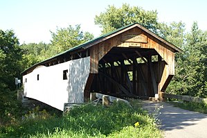
| Poland Covered Bridge | |
|---|---|
 Bridge in U.S. state of Vermont Bridge in U.S. state of Vermont | |
| Coordinates | 44°39′04″N 72°48′50″W / 44.651°N 72.814°W / 44.651; -72.814 |
| Carries | Automobile |
| Crosses | Lamoille River |
| Locale | Cambridge, Vermont |
| Maintained by | Town of Cambridge |
| ID number | VT-08-02 |
| Characteristics | |
| Design | Covered, Burr arch |
| Material | Wood |
| Total length | 152.9 ft (46.60 m) |
| Width | 15.7 ft (4.79 m) |
| No. of spans | 1 |
| Load limit | 3 tons |
| Clearance above | 11.5 ft (3.51 m) |
| History | |
| Constructed by | George W. Holmes |
| Construction end | 1887 |
| U.S. National Register of Historic Places | |
  | |
| Coordinates | 44°39′04″N 72°48′52″W / 44.65111°N 72.81444°W / 44.65111; -72.81444 |
| Area | 1 acre (0.4 ha) |
| NRHP reference No. | 74000230 |
| Added to NRHP | October 9, 1974 |
The Poland Covered Bridge, also known as the Junction Covered Bridge or the Cambridge Junction Covered Bridge is a covered bridge that carries Cambridge Junction Road across the Lamoille River off State Route 15 in Cambridge, Vermont. It was listed on the National Register of Historic Places in 1974. The bridge is of Burr arch design, built by George W. Holmes in 1887.
Name
The bridge was named for a local official, Judge Poland, and was a controversial issue in 1888:
- "Judge Poland has caused the Town of Cambridge to be inflicted with a bridge and a road at an expense of from $6,000-$10,000 which as shown will be of no material benefit to anyone but himself. It will be known in the future as “Poland’s Bridge” except to the taxpayers of Cambridge who will christen it “The Bridge of Sighs.” " –News & Citizen, 1888
Poland did not live to use the bridge, dying in his hayfield the following July.
Description
The Poland Covered Bridge is located a short way east of the village of Jeffersonville, and is oriented roughly north-south across the west-flowing Lamoille River, on Cambridge Junction Road, which connects Vermont Route 15 on the south side of the river with Vermont Route 109 on the north side. The bridge is 152.5 feet (46.5 m) long and 19.5 feet (5.9 m) wide, with a roadway width of 15.5 feet (4.7 m) (one lane). It is supported by flanking Burr trusses, which include laminated arches embedded in the truss structure. The deck is further supported by a laminated beam that has been bolted to its underside. The bridge rests on stone abutments that have been capped in concrete. The exterior is clad in vertical board siding, which extend around to the insides of the portals. On the sides, the siding ends short of the roof, following the curve of the truss arches at the center.
Recent history
Deterioration over time introduced a lean to the bridge, but in 1995 a vehicle struck one of the king posts which straightened out the lean, but caused the support system to start failing. Reconstruction on the bridge began in 2003 by Alpine Construction and it was reopened on July 4, 2004. The project was supported by the National Historic Bridge Program which provided $1 million to preserving the bridge The bridge now has short "tire rails" on each side of the traveled lane to prevent vehicles from striking the sides again. At last visit, it appears they are working, as they show evidence of having been struck.

See also
- National Register of Historic Places listings in Lamoille County, Vermont
- List of Vermont covered bridges
- List of bridges on the National Register of Historic Places in Vermont
Notes
- As stated on the sign affixed to the bridge, and State of Vermont Historical marker
References
- ^ "National Register Information System". National Register of Historic Places. National Park Service. July 9, 2010.
- U.S. Geological Survey Geographic Names Information System: Poland Covered Bridge
- News & Citizen, Morrisville, VT, 1888.
- Hugh Henry (1974). "NRHP nomination for Poland Covered Bridge". National Park Service. Retrieved 2016-12-20. with photos from 1974
- Barna, Ed. Covered Bridges of Vermont. The Countryman Press, 1996. ISBN 0-88150-373-8
- Nelson, Joe. "Cambridge Junction Covered Bridge Opened". Vermont Covered Bridge Society Archives Website. 2009-07-05.
- Marsh, Roberta. Cambridge Historical Society
- Buildings and structures in Cambridge, Vermont
- Bridges completed in 1887
- Covered bridges on the National Register of Historic Places in Vermont
- King post truss bridges in the United States
- Wooden bridges in Vermont
- Covered bridges in Lamoille County, Vermont
- National Register of Historic Places in Lamoille County, Vermont
- Road bridges on the National Register of Historic Places in Vermont
- Burr Truss bridges in the United States
- 1887 establishments in Vermont
