| Ponikva pri Žalcu | |
|---|---|
 | |
 | |
| Coordinates: 46°18′49.49″N 15°8′8.49″E / 46.3137472°N 15.1356917°E / 46.3137472; 15.1356917 | |
| Country | |
| Traditional region | Styria |
| Statistical region | Savinja |
| Municipality | Žalec |
| Area | |
| • Total | 5.31 km (2.05 sq mi) |
| Elevation | 418.5 m (1,373.0 ft) |
| Population | |
| • Total | 339 |
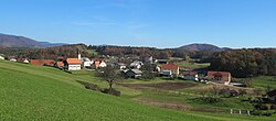
Ponikva pri Žalcu (pronounced [ˈpoːnikʋa pɾi ˈʒaːu̯tsu]) is a village in the Municipality of Žalec in east-central Slovenia. It lies in the Ložnica Hills (Slovene: Ložniško gričevje) northwest of Žalec. The area is part of the traditional region of Styria. The municipality is now included in the Savinja Statistical Region.
History
The settlement of Ponikva pri Žalcu was created in 1953, when the formerly separate villages of Spodnja Ponikva and Zgornja Ponikva were merged into a single settlement.
Church
The parish church in the settlement is dedicated to Saint Pancras (Slovene: sveti Pankracij) and belongs to the Roman Catholic Diocese of Celje. It was a 16th-century building that was rebuilt in 1925.
References
- Statistical Office of the Republic of Slovenia
- Žalec municipal site
- Marinković, Dragan (1991). Abecedni spisak naselja u SFRJ. Promene u sastavu i nazivima naselja za period 1948–1990. Belgrade: Savezni zavod za statistiku. pp. 80, 95, 120.
- Slovenian Ministry of Culture register of national heritage reference number ešd 2988
External links
This article about the Municipality of Žalec in Slovenia is a stub. You can help Misplaced Pages by expanding it. |
