Town in Saskatchewan, Canada
| Ponteix | |
|---|---|
| Town | |
| Town of Ponteix | |
 Ponteix town hall Ponteix town hall | |
  | |
| Coordinates: 49°44′51″N 107°29′18″W / 49.7476°N 107.4883°W / 49.7476; -107.4883 | |
| Country | Canada |
| Province | Saskatchewan |
| Post office Founded | 1908-10-01 |
| Government | |
| • Mayor | David Scully |
| • Town Manager | Lynne Lemieux |
| • Governing body | Ponteix Town Council |
| • MLA | Dave Marit |
| • MP | Jeremy Patzer |
| Area | |
| • Total | 1.09 km (0.42 sq mi) |
| Population | |
| • Total | 577 |
| • Density | 485.2/km (1,257/sq mi) |
| Time zone | UTC−6 (Central Standard Time) |
| Postal code | S0N 1Z0 |
| Area code | 306 |
| Highways | Highway 13 Highway 612 |
| Website | www |
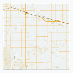
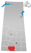
Ponteix (/ˈpɒntɛks/, PON-teks) is a town in southwestern Saskatchewan, Canada, 86 kilometres (53 mi) southeast of Swift Current. It is on Highway 628, just north of Highway 13.
History
In 1908, Father Albert-Marie Royer from the Auvergne region in France established a parish and hamlet called Notre-Dame d’Auvergne north of Notukeu Creek. Five years later, the townsite was moved south of the creek when the Canadian Pacific Railway laid track there. After the move, the community was renamed Ponteix after Father Royer's former parish in France (Le Ponteix, commune of Aydat).
Demographics
In the 2021 Census of Population conducted by Statistics Canada, Ponteix had a population of 577 living in 242 of its 276 total private dwellings, a change of 2.5% from its 2016 population of 563. With a land area of 1.19 km (0.46 sq mi), it had a population density of 484.9/km (1,255.8/sq mi) in 2021.
Climate
| Climate data for Ponteix, Saskatchewan | |||||||||||||
|---|---|---|---|---|---|---|---|---|---|---|---|---|---|
| Month | Jan | Feb | Mar | Apr | May | Jun | Jul | Aug | Sep | Oct | Nov | Dec | Year |
| Record high °C (°F) | 10.6 (51.1) |
5.8 (42.4) |
13.9 (57.0) |
21.4 (70.5) |
29.6 (85.3) |
32.8 (91.0) |
34.5 (94.1) |
34.1 (93.4) |
32.0 (89.6) |
23.6 (74.5) |
15.0 (59.0) |
9.1 (48.4) |
34.5 (94.1) |
| Mean daily maximum °C (°F) | −9.6 (14.7) |
−11.6 (11.1) |
−5.8 (21.6) |
3.7 (38.7) |
11.2 (52.2) |
17.4 (63.3) |
21.0 (69.8) |
20.2 (68.4) |
13.1 (55.6) |
5.1 (41.2) |
−6.0 (21.2) |
−9.5 (14.9) |
4.3 (39.7) |
| Daily mean °C (°F) | −14.4 (6.1) |
−16.8 (1.8) |
−10.6 (12.9) |
−2.0 (28.4) |
5.3 (41.5) |
11.1 (52.0) |
14.1 (57.4) |
13.1 (55.6) |
6.8 (44.2) |
0.1 (32.2) |
−10.0 (14.0) |
−13.8 (7.2) |
−2.1 (28.2) |
| Mean daily minimum °C (°F) | −19.1 (−2.4) |
−22.0 (−7.6) |
−15.4 (4.3) |
−8.0 (17.6) |
0.5 (32.9) |
4.7 (40.5) |
7.1 (44.8) |
5.9 (42.6) |
0.6 (33.1) |
−4.9 (23.2) |
−14.8 (5.4) |
−18.1 (−0.6) |
−6.4 (20.5) |
| Record low °C (°F) | −39.0 (−38.2) |
−43.5 (−46.3) |
−34.4 (−29.9) |
−27.5 (−17.5) |
−15.0 (5.0) |
−6.4 (20.5) |
−2.5 (27.5) |
−3.5 (25.7) |
−11.5 (11.3) |
−26.5 (−15.7) |
−35.5 (−31.9) |
−39.5 (−39.1) |
−43.5 (−46.3) |
| Average precipitation mm (inches) | 16 (0.6) |
9 (0.4) |
15 (0.6) |
23 (0.9) |
55 (2.2) |
70 (2.8) |
61 (2.4) |
47 (1.9) |
27 (1.1) |
18 (0.7) |
15 (0.6) |
17 (0.7) |
363 (14.3) |
| Average snowfall cm (inches) | 16 (6.3) |
14 (5.4) |
12 (4.7) |
4.8 (1.9) |
0.76 (0.3) |
0.0 (0.0) |
0.0 (0.0) |
0.0 (0.0) |
0.25 (0.1) |
3.6 (1.4) |
7.9 (3.1) |
14 (5.5) |
73 (28.7) |
| Average precipitation days | 6.9 | 5.1 | 6.3 | 5.9 | 8.4 | 8.4 | 7.4 | 6.3 | 5.8 | 5.6 | 6.7 | 6.8 | 80.6 |
| Average snowy days | 9.2 | 7.5 | 6.4 | 2.7 | 0.4 | 0.0 | 0.0 | 0.0 | 0.2 | 2.4 | 6.6 | 9.4 | 45.8 |
| Average relative humidity (%) | 77 | 70 | 62 | 55 | 51 | 54 | 55 | 57 | 59 | 63 | 71 | 77 | 63 |
| Mean monthly sunshine hours | 95.0 | 118.0 | 177.0 | 224.0 | 285.0 | 330.0 | 348.0 | 313.0 | 243.0 | 166.0 | 91.0 | 71.0 | 2,451 |
According to the 2011 federal census, 175 of Ponteix's residents spoke both official languages (English and French).
Canada census – Ponteix community profile| 2021 | 2011 | |
|---|---|---|
| Population | 577 (+2.5% from 2016) | 605 (+13.9% from 2006) |
| Land area | 1.19 km (0.46 sq mi) | 1.09 km (0.42 sq mi) |
| Population density | 485.2/km (1,257/sq mi) | 556.0/km (1,440/sq mi) |
| Median age | 46 (M: 43.6, F: 48.8) | 51.6 (M: 47.0, F: 55.8) |
| Private dwellings | 245 (total) | 268 (total) |
| Median household income |
Notukeu Regional Park
Notukeu Regional Park (49°45′00″N 107°29′07″W / 49.7501°N 107.4854°W / 49.7501; -107.4854) is a regional park along the banks of Notukeu Creek and adjacent to Ponteix. The park has a campground, golf course, spray park, and swimming pool. It is a small park that was founded in 1964.
The campground has 30 serviced campsites plus a tenting area. The Ponteix Golf Club has grass greens and is a 9-hole, par 33 course that totals 2,485 yards. There is a licensed clubhouse and pro shop.
Attractions
- Plesiosaur Statue: Near Ponteix was the site of a plesiosaur find in the early 1990s. In 1995 community members and students of Ponteix school contributed small articles to this plesiosaur statue before it was filled with cement and painted by the townspeople in a ceremony commemorating the discovery of the original plesiosaur's bones.
- Notukeu Heritage Museum in Ponteix features prehistoric artifacts.
- Notre Dame D'Auvergne Catholic Church, a brick and concrete structure in Ponteix built in 1929, features twin steeples and houses a large wood carving of the Pieta. The Pieta statue came to Canada in 1909 and was saved when the 1916 church was destroyed by fire in 1923. A description of the oak statue in 1954 by Abbot Jerome Webber of St. Peter's Abbey claims it was made in France over four hundred years ago, was saved by peasants during the French Revolution and was once covered in pure gold.
Notable residents
See also
- List of communities in Saskatchewan
- List of francophone communities in Saskatchewan
- List of towns in Saskatchewan
References
- ^ "2011 Community Profiles". Statistics Canada. Government of Canada. Retrieved 2 August 2014.
- National Archives, Archivia Net. "Post Offices and Postmasters". Retrieved 22 November 2013.
- Government of Saskatchewan, MRD Home. "Municipal Directory System". Retrieved 22 November 2013.
- "Notukeu Creek". Canadian Geographical Names Database. Government of Canada. Retrieved 21 July 2023.
- "Town of Ponteix website". Retrieved 20 December 2012.
- "Population and dwelling counts: Canada, provinces and territories, census divisions and census subdivisions (municipalities), Saskatchewan". Statistics Canada. 9 February 2022. Retrieved 1 April 2022.
- "2021 Community Profiles". 2021 Canadian census. Statistics Canada. 4 February 2022. Retrieved 27 April 2022.
- "2011 Community Profiles". 2011 Canadian census. Statistics Canada. 21 March 2019. Retrieved 20 December 2012.
- "2006 Community Profiles". 2006 Canadian census. Statistics Canada. 20 August 2019.
- "2001 Community Profiles". 2001 Canadian census. Statistics Canada. 18 July 2021.
- "Notukeu Regional Park". Canadian Geographical Names Database. Government of Canada. Retrieved 22 July 2023.
- "Notukeu Regional Park". Tourism Saskatchewan. Government of Saskatchewan. Retrieved 23 July 2023.
- "Notukeu". Regional Parks of Saskatchewan. Saskatchewan Regional Parks. Retrieved 23 July 2023.
- "Ponteix Golf Club". GolfPass. GolfPass. Retrieved 23 July 2023.
- "Big Things (Village of Ponteix, Saskatchewan)". Retrieved 20 December 2012.
- "Museums Association of Saskatchewan (Notukeu Heritage Museum)". Retrieved 20 December 2012.
- "Notre Dame D'Auvergne Catholic Church". Archived from the original on 22 February 2004. Retrieved 20 December 2012.
- "Saskatchewan's Marian Shrines". Retrieved 20 December 2012.
| Places adjacent to Ponteix | ||||||||||||||||
|---|---|---|---|---|---|---|---|---|---|---|---|---|---|---|---|---|
| ||||||||||||||||
49°44′51″N 107°29′18″W / 49.7476°N 107.4883°W / 49.7476; -107.4883 (Ponteix, Saskatchewan)
Categories: