| Port-Bouët | |
|---|---|
| Suburb and urban commune | |
 Location in Abidjan Location in Abidjan | |
 | |
| Coordinates: 5°16′N 3°54′W / 5.267°N 3.900°W / 5.267; -3.900 | |
| Country | |
| District | Abidjan |
| Area | |
| • Total | 73.77 km (28.48 sq mi) |
| Population | |
| • Total | 618,795 |
| • Density | 8,400/km (22,000/sq mi) |
| Time zone | UTC+0 (GMT) |
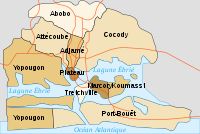
Port-Bouët is a suburb of Abidjan, Ivory Coast. It is one of the 10 urban communes of the city. Port-Bouët is one of four communes of Abidjan that are entirely south of Ébrié Lagoon, the others being Treichville, Koumassi, and Marcory.
Port-Bouët had not been inhabited until around 1930. The Port Bouët/Petit Bassam lighthouse (French: Phare de Port Bouët (Petit Bassam)) was built in the early 1930s.
Félix-Houphouët-Boigny International Airport (French: Aéroport international Félix Houphouët-Boigny or Aéroport international Abidjan) is located in Port-Bouët.
References
- citypopulation.de Population of boroughs and sub-prefectures of Abidjan
- Rowlett, Russ. "Lighthouses of Côte d'Ivoire (Ivory Coast)". The Lighthouse Directory. University of North Carolina at Chapel Hill.
- "Port Bouët/Petit Bassam Light - ARLHS ICO-002".
 | Urban communes (north) |  | |
|---|---|---|---|
| Urban communes (south) | |||
| Rural sub-prefectures (east) | |||
| Rural sub-prefectures (west) | |||
This Abidjan location article is a stub. You can help Misplaced Pages by expanding it. |