| Portneuf River | |
|---|---|
 | |
 | |
| Native name | Rivière Portneuf (French) |
| Location | |
| Country | Canada |
| Province | Quebec |
| Region | Capitale-Nationale, Mauricie |
| Regional County Municipality | Portneuf Regional County Municipality |
| Municipalities | Pont-Rouge, Saint-Basile |
| Physical characteristics | |
| Source | Sept Îles Lake (Saint-Raymond) |
| • location | Saint-Raymond, MRC Portneuf Regional County Municipality, Capitale-Nationale, Quebec, Canada |
| • coordinates | 46°56′02″N 71°44′48″W / 46.93389°N 71.74667°W / 46.93389; -71.74667 |
| • elevation | 209 m (686 ft) |
| Mouth | Saint Lawrence river |
| • location | Portneuf |
| • coordinates | 46°56′02″N 71°48′24″W / 46.93389°N 71.80666°W / 46.93389; -71.80666 |
| • elevation | 5 m (16 ft) |
| Length | 55 km (34 mi) |
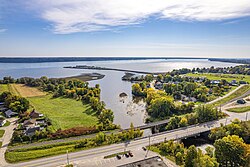
The Rivière Portneuf is a tributary of the north shore of the Saint-Laurent river, crossing the municipalities of Saint-Raymond, Pont-Rouge, Sant-Basile and Portneuf, in the Portneuf Regional County Municipality, in the administrative region of the Capitale-Nationale, in the province of Quebec, in Canada.
Toponymy
The name of this river is linked to the seigniory of Portneuf which it crosses before flowing into the Saint Lawrence river. Although this seigniory was allotted in 1636, the act of the concession was confirmed in 1647.
The toponym "Rivière Portneuf" was formalized on December 5, 1968, at the Place Names Bank of the Commission de toponymie du Québec.
See also
References
- Source: "Names and places of Quebec", work of the Commission of toponymy of Quebec, appeared in 1994 and 1996 in the form of a printed illustrated dictionary, and in that of a CD made by the company Micro-Intel, in 1997, from this dictionary.
- Commission de toponymie du Québec - Bank of Place Names - Toponym: Rivière Portneuf
Download coordinates as:
Categories: