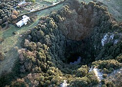
| Pozzo del Merro | |
|---|---|
 | |
| Location | Sant'Angelo Romano, Lazio, Italy |
| Coordinates | 42°02′21″N 12°40′50″E / 42.039298°N 12.680456°E / 42.039298; 12.680456 |
| Depth | c. 392 m |
Pozzo del Merro is a flooded sinkhole in the countryside northeast of Rome, Italy. Situated at the bottom of an 80 m conical pit, at 392 m (1,286 ft) it is the second deepest underwater vertical cave in the world. In 2000 two ROVs were sent to explore its depths; the first, the "Mercurio (Mercury)" reached its maximum operative depth of 210 m (690 ft) without reaching the bottom. The second ROV, "Hyball 300", reached 310 m (1,020 ft) without touching down either. A third dive in 2002 with the more advanced "Prometeo" robot reached the bottom at 392 m (1,286 ft), but discovered a narrow passage continuing horizontally.
The sinkhole, similar to the Zacatón cenote, was formed by volcanic activity eroding the carbonate rock.
References
- ^ Ant, Simon. "MSTD - Caves and Wrecks technically explored !". web.infinito.it. Retrieved 2018-08-24.
- "VOLCANICALLY INFLUENCED SPELEOGENESIS: FORMING EL SISTEMA ZACATÓN, MEXICO AND POZZO MERRO, ITALY, THE DEEPEST PHREATIC SINKHOLES IN THE WORLD". gsa.confex.com. Retrieved 2018-08-24.
42°02′21″N 12°40′50″E / 42.0393°N 12.6805°E / 42.0393; 12.6805
This geology article is a stub. You can help Misplaced Pages by expanding it. |