| Praia Grande | |
|---|---|
| Municipality | |
| The Municipality of Praia Grande | |
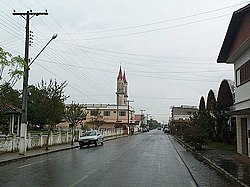
 Irineu Bornhausen Street in downtown Praia Grande. Irineu Bornhausen Street in downtown Praia Grande. | |
 Seal Seal | |
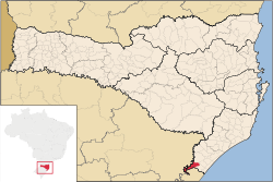
 Location of Praia Grande Location of Praia Grande | |
| Coordinates: 29°11′49″S 49°57′00″W / 29.19694°S 49.95000°W / -29.19694; -49.95000 | |
| Country | |
| Region | South |
| State | Santa Catarina |
| Founded | July 19, 1958 |
| Government | |
| • Mayor | João José de Matos (PMDB) |
| Area | |
| • Total | 278.576 km (107.559 sq mi) |
| Elevation | 45 m (148 ft) |
| Population | |
| • Total | 7,312 |
| • Density | 25.4/km (66/sq mi) |
| Time zone | UTC-3 (UTC-3) |
| • Summer (DST) | UTC-2 (UTC-2) |
| HDI (2000) | 0.763 – medium |
| Website | www.praiagrande-sc.gov.br |
Praia Grande is the southernmost municipality in the Brazilian state of Santa Catarina. Despite its name (which means Great Beach in Portuguese), the city is landlocked.
References
| Sul Catarinense mesoregion of Santa Catarina | |
|---|---|
| |
| Araranguá | |
| Criciúma | |
| Tubarão | |
This Santa Catarina, Brazil location article is a stub. You can help Misplaced Pages by expanding it. |