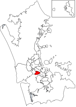
Local board of Puketāpapa in Auckland, New Zealand
| Puketāpapa Local Board Te Poari ā-Rohe o Puketāpapa | |
|---|---|
| Local board of Puketāpapa | |
 Puketāpapa Local Board area in Auckland Puketāpapa Local Board area in Auckland | |
| Country | New Zealand |
| Region | Auckland |
| Territorial authority | Auckland |
| Ward | Albert-Eden-Puketāpapa ward |
| Legislated | 2010 |
| Area | |
| • Land | 18.72 km (7.23 sq mi) |
| Population | |
| • Total | 64,000 |
| Local Board Members | |
|---|---|
| Leadership | |
| Chairperson | Ella Kumar JP, C & R |
| Deputy chairperson | Fiona Lai, C & R |
| Structure | |
| Seats | 6 |
| Political groups | |
| Length of term | 3 years |
| Elections | |
| Last election | 2022 |
| Next election | 2025 |
| Meeting place | |
| 560 Mt Albert Road, Three Kings, Auckland | |
The Puketāpapa Local Board is one of the 21 local boards of the Auckland Council, and is one of the two boards overseen by the council's Albert-Eden-Puketāpapa ward councilors.
The Puketāpapa board, named after the Māori name for Mount Roskill, covers the suburbs of Hillsborough, Lynfield, Mount Roskill, Three Kings, Waikowhai, and Wesley.
The board is governed by six board members elected at-large. The first board members were elected by the nationwide local elections, which were held on Saturday 9 October 2010.
Demographics
Puketāpapa Local Board Area covers 18.72 km (7.23 sq mi) and had an estimated population of 64,000 as of June 2024, with a population density of 3,419 people per km.
| Year | Pop. | ±% p.a. |
|---|---|---|
| 2006 | 50,802 | — |
| 2013 | 52,938 | +0.59% |
| 2018 | 57,555 | +1.69% |
| 2023 | 56,949 | −0.21% |
| Source: | ||
| Ethnicity | Population |
|---|---|
| New Zealand European | 18,261 |
| Māori | 3,795 |
| Pasifika | 8,931 |
| Asian | 28,701 |
| MELAA | 2,610 |
| Other | 414 |
Puketāpapa had a population of 56,949 in the 2023 New Zealand census, a decrease of 606 people (−1.1%) since the 2018 census, and an increase of 4,011 people (7.6%) since the 2013 census. There were 19,701 dwellings. The median age was 35.7 years (compared with 38.1 years nationally). There were 9,549 people (16.8%) aged under 15 years, 13,083 (23.0%) aged 15 to 29, 26,043 (45.7%) aged 30 to 64, and 8,277 (14.5%) aged 65 or older.
Ethnicities were 32.1% European/Pākehā, 6.7% Māori, 15.7% Pasifika, 50.4% Asian, 4.6% Middle Eastern, Latin American and African New Zealanders, and 0.7% other. People may identify with more than one ethnicity.
Puketāpapa Local Board Area had a population of 57,555 at the 2018 New Zealand census. There were 17,328 households, comprising 28,677 males and 28,878 females, giving a sex ratio of 0.99 males per female.
The percentage of people born overseas was 52.7, compared with 27.1% nationally.
Although some people chose not to answer the census's question about religious affiliation, 32.1% had no religion, 36.6% were Christian, 0.3% had Māori religious beliefs, 14.0% were Hindu, 7.4% were Muslim, 2.4% were Buddhist and 2.5% had other religions.
Of those at least 15 years old, 16,167 (34.1%) people had a bachelor's or higher degree, and 5,763 (12.1%) people had no formal qualifications. The median income was $30,100, compared with $31,800 nationally. 7,668 people (16.2%) earned over $70,000 compared to 17.2% nationally. The employment status of those at least 15 was that 23,505 (49.5%) people were employed full-time, 6,654 (14.0%) were part-time, and 1,908 (4.0%) were unemployed.
2022–2025 term
The board members, elected at the 2022 local body elections, in election order:
- Ella Kumar, C&R – Communities and Residents, (6682 votes)
- Roseanne Hay, C&R – Communities and Residents, (6670 votes)
- Fiona Lai, C&R – Communities and Residents, (6236 votes)
- Jon Turner, Roskill Community Voice, (5421 votes)
- Bobby Shen, Roskill Community Voice, (5317 votes)
- Mark Pervan, C&R – Communities and Residents, (4882 votes)
2019–2022 term
The board members, elected at the 2019 local body elections, in election order:
- Ella Kumar, C&R – Communities and Residents, (6528 votes)
- Julie Fairey, Roskill Community Voice, (6390 votes)
- Jon Turner, Roskill Community Voice, (6157 votes)
- Fiona Lai, C&R – Communities and Residents, (5956 votes)
- Bobby Shen, Roskill Community Voice, (5693 votes)
- Harry Doig, Roskill Community Voice, (5545 votes)
References
- ^ "ArcGIS Web Application". statsnz.maps.arcgis.com. Retrieved 25 February 2022.
- ^ "Aotearoa Data Explorer". Statistics New Zealand. Retrieved 26 October 2024.
- "Puketāpapa Local Board map" (PDF). Retrieved 27 October 2020.
- ^ "Statistical area 1 dataset for 2018 Census". Statistics New Zealand. March 2020. Puketāpapa Local Board Area (CMB07613). 2018 Census place summary: Puketāpapa Local Board Area
- ^ "2023 Census national and subnational usually resident population counts and dwelling counts" (Microsoft Excel). Stats NZ - Tatauranga Aotearoa. Retrieved 29 May 2024.
- "Local elections 2022 – Local board member official results" (PDF). Auckland Council. 15 October 2022. Retrieved 15 October 2022.
- "Local board members" (PDF). Auckland Council. 18 October 2019. Retrieved 21 October 2019.
| Auckland Council | |||||||||||||||||||||||||||||||||||||||||||||||||||||||||||||||||||||
|---|---|---|---|---|---|---|---|---|---|---|---|---|---|---|---|---|---|---|---|---|---|---|---|---|---|---|---|---|---|---|---|---|---|---|---|---|---|---|---|---|---|---|---|---|---|---|---|---|---|---|---|---|---|---|---|---|---|---|---|---|---|---|---|---|---|---|---|---|---|
| Wards Local Boards Local Subdivisions |
| ||||||||||||||||||||||||||||||||||||||||||||||||||||||||||||||||||||
| Regional parks |
| ||||||||||||||||||||||||||||||||||||||||||||||||||||||||||||||||||||
| Former councils | |||||||||||||||||||||||||||||||||||||||||||||||||||||||||||||||||||||
| Puketāpapa Local Board Area, Auckland, New Zealand | |
|---|---|
| Populated places | |
| Geographic features | |
| Facilities and attractions | |
| Government | |
| Organisations | |
36°54′31.93″S 174°45′28.73″E / 36.9088694°S 174.7579806°E / -36.9088694; 174.7579806
Category: