| Punta Sulè | |
|---|---|
| Ponta Solé | |
 | |
| Highest point | |
| Elevation | 3,384 m (11,102 ft) |
| Prominence | 311 m (1,020 ft) |
| Isolation | 2.85 km (1.77 mi) |
| Listing | Alpine mountains above 3000 m |
| Coordinates | 45°13′51.6″N 07°08′13.2″E / 45.231000°N 7.137000°E / 45.231000; 7.137000 |
| Geography | |
 | |
| Location | Piedmont, Italy |
| Parent range | Graian Alps |
| Climbing | |
| First ascent | Filippo Vallino |
| Easiest route | Scrambling |
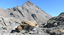
Punta Sulè (in Piedmontese Ponta Solé) is a 3,384 m a.s.l.mountain of the Graian Alps, located in Italy.
Geography


The mountain is the highest elevation of the ridge between the terminal dales of the Stura di Viù valley, Peraciaval (North) and Malciaussia (South). Going NW the Sulè pass divides Punta Sulè from Testa Sulà (3,073 m a.s.l.), while going East the Colletto della Lera (3,320 m a.s.l.) separates it from Monte Lera.
Administratively the mountain belongs to the Usseglio municipality (comune).
On the summit a cairn bears a small Jesus Christ statue; on another nearby cairn is located a lightning rod. In clear days it offers a good view of many important mountains of Western Alps including Argentera group, Viso, Dauphiné Alps, Bianco, Gran Paradiso and Rosa.
SOIUSA classification
According to the SOIUSA (International Standardized Mountain Subdivision of the Alps) the mountain can be classified in the following way:
- main part = Western Alps
- major sector = North Western Alps
- section = Graian Alps
- subsection = South-Eastern Graian Alps
- supergroup = Catena Arnas-Ciamarella
- group = Gruppo Autaret-Ovarda
- subgroup = Cresta Autaret-Lera-Arnas
- code = I/B-7.I-B.4.a
History
The first recorded ascent to Punta Sulè was carried out by Filippo Vallino on August 16, 1880.
Access to the summit
The usual route to Punta Sulè starts from lago di Malciaussia and, after Pian Sulè, reaches the summit following the SW ridge of the mountain. While long (around 1,600 metres of vertical drop) this route does not require alpinistic skills but just scrambling. In the Italian scale of hiking difficulty is rated EE (Escursionisti Esperti, namely suitable for expert hikers). Traverse from Punta Sulè to Monte Lera is considered an alpinistic route, evaluated of PD grade.
References
![]() Media related to Punta Sulè at Wikimedia Commons
Media related to Punta Sulè at Wikimedia Commons
- ^ "Punta Sulè, Italy". peakbagger.com. Retrieved 2017-02-12.
- ^ Berutto, Giulio (1983). Valli di Lanzo e Moncenisio. Torino: Istituto Geografico Centrale.
- ^ Carta IGM 1:25.000 scale, see www.pcn.minambiente.it (access: February 2017)
- ^ Andrea81 (2009-07-30). "Sulè (Punta) dal Lago di Malciaussia". Retrieved 2017-02-12.
{{cite web}}: CS1 maint: numeric names: authors list (link) - Marazzi, Sergio (2005). Atlante Orografico delle Alpi. SOIUSA (in Italian). Priuli & Verlucca. p. 134. ISBN 978-88-8068-273-8.
- r.fausone (2010-07-11). "Lera (Monte) e Punta Sulè da Malciaussia, anello di cresta". Retrieved 2017-02-12.
Maps
- Istituto Geografico Militare (IGM) official maps of Italy, 1:25.000 and 1:100.000 scale, on-line version
- Istituto Geografico Centrale (IGC) - Carta dei sentieri e dei rifugi scala 1:50.000 n. 2 Valli di Lanzo e Moncenisio
- Istituto Geografico Centrale - Carta dei sentieri e dei rifugi scala 1:25.000 n.110 Alte Valli di Lanzo (Rocciamelone - Uja di Ciamarella - Le Levanne)