Municipality in South Governorate, Lebanon
| Qaitouli قيتوليKaitouli | |
|---|---|
| Municipality | |
 The Lebanese municipality of Qaitouli as it looks from the Haitoura – Jezzine road. The Lebanese municipality of Qaitouli as it looks from the Haitoura – Jezzine road. | |
 | |
| Coordinates: 33°32′15″N 35°33′07″E / 33.53750°N 35.55194°E / 33.53750; 35.55194 | |
| Country | |
| Governorate | South Governorate |
| District | Jezzine District |
| Elevation | 950 m (3,120 ft) |
| Distance from the Capital Beirut | 72 km |
Qaitouli (Arabic: قيتولي) is a municipality in the Jezzine District of South Governorate in Lebanon. Qaitouli is about 72 km from the capital Beirut.
Etymology
Qaitouli come from a Syriac word which means "Gods residence".
Demographics
In 2014, Christians made up 99.00% of registered voters in Qaitouli. 64.11% of the voters were Maronite Catholics and 29.51% were Greek Catholics.
Monuments
Monuments in Qaitouli include Mar Mikhael (Saint Michael) ancient church (built around 1811), heritage houses, an old press, ruins of an old press, and that of old mills.
Natural attractions
A visitor to the area can find human traces in the nature such as coal quarries and mines, and purely natural spots including the Mar Gergess (Saint George) spring, the Al-Houwwa (Arabic for pit) in the area of Dahr Al-Makla'a, and the pine woods dispersed around the village.
Developmental projects
Of the developmental projects that are helping Qaitouli:
Geology
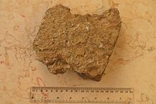
From a geological point of view, the land of Qaitouli is principally made of sediments that originate from the event of the formation of the Mount Lebanon where parts of the crust was raised from below the Mediterranean Sea to elevations reaching 3,088 m at the Qurnat as Sawda'.
-
 Sedimentary rocks found in Kaitouly and containing fossiled marine creatures
-
 A close-up view of sedimentary rock above showing remains of seashells
Notable people
- Ounsi el-Hajj - Poet
- Hector Hajjar - Minister of Social Affairs
See also
References
- South Lebanon (PDF). p. 32. Retrieved 29 May 2017.
- Freyha, Anis (1996). A Dictionary of the Names of Towns and Villages in Lebanon (Fourth ed.). Librairie du Liban. p. 143.
- "التوزيع حسب المذاهب للناخبين/ناخبات في بلدة قيتولي، قضاء جزين محافظة الجنوب في لبنان". إعْرَفْ لبنان.
- South Lebanon (PDF). p. 29. Retrieved 29 May 2017.
- South Lebanon (PDF). p. 29. Retrieved 29 May 2017.
- "Carob Grinder for Kaitouly Village". UNDP. Retrieved 5 June 2017.
- "1 Building Alliance for Local Advancement, Development and Investment – BALADI Project Funded by the United States Agency for International Development – USAID List of New Selected Projects under Ren é Moawad Foundation Scope & Caritas Lebanon Scope" (PDF). Baladi. Archived from the original on 3 April 2019. Retrieved 5 June 2017.
- "Lebanese poet Ounsi el-Hajj, 77, dies". Al Akhbar. Archived from the original on 22 December 2014. Retrieved 30 May 2017.
External links
- Qaytouli, localiban
