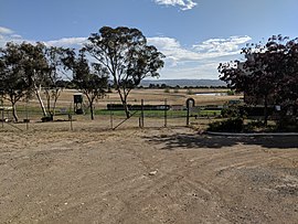
Suburb of Queanbeyan, New South Wales, Australia
| Queanbeyan West Queanbeyan, New South Wales | |||||||||||||||
|---|---|---|---|---|---|---|---|---|---|---|---|---|---|---|---|
 Queanbeyan Race Course Queanbeyan Race Course | |||||||||||||||
 | |||||||||||||||
| Coordinates | 35°21′26″S 149°12′32″E / 35.3572°S 149.2090°E / -35.3572; 149.2090 | ||||||||||||||
| Population | 3,146 (2021 census) | ||||||||||||||
| Postcode(s) | 2620 | ||||||||||||||
| LGA(s) | Queanbeyan-Palerang Regional Council | ||||||||||||||
| County | Murray | ||||||||||||||
| Parish | Queanbeyan | ||||||||||||||
| State electorate(s) | Monaro | ||||||||||||||
| Federal division(s) | Eden-Monaro | ||||||||||||||
| |||||||||||||||
Queanbeyan West is a suburb of Queanbeyan, New South Wales, Australia. Queanbeyan West is located west of the central business district (CBD) and also borders the Australian Capital Territory, it is located south of Crestwood and Canberra Avenue and west of Tharwa Road. At the 2021 census, it had a population of 3,146.
References
- ^ Australian Bureau of Statistics (28 June 2022). "Queanbeyan West". 2021 Census QuickStats. Retrieved 26 September 2022.

- "Queanbeyan West". Geographical Names Board of New South Wales. New South Wales Government. Retrieved 16 July 2017.
| Queanbeyan suburbs | |
|---|---|
| Localities and rural places |
|
| Main Article: Local government areas of New South Wales | |
This Southern Tablelands geography article is a stub. You can help Misplaced Pages by expanding it. |