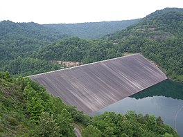
| R. D. Bailey Lake | |
|---|---|
 Dam Dam | |
  | |
| Location | Wyoming / Mingo counties, West Virginia, United States |
| Coordinates | 37°36′00″N 81°49′20″W / 37.60000°N 81.82222°W / 37.60000; -81.82222 |
| Type | reservoir |
| Primary inflows | Guyandotte River |
| Primary outflows | Guyandotte River |
| Basin countries | United States |
| Surface elevation | 1,043 feet (318 m) |
R. D. Bailey Lake is located on the Guyandotte River in Wyoming and Mingo Counties in West Virginia, 3.3 miles (5.3 km) east of Justice. Originally referred to as Justice Reservoir, the lake was named by Congressional action, Public Law 90-46, on July 4, 1967 for Robert D. Bailey, Sr., a prominent jurist, diarist, and citizen of Pineville. R. D. Bailey lake was dedicated in August 1980.
The R. D. Bailey Dam is 310 feet (94 m) high with a top length of 1,370 feet (420 m). A minimum pool with a surface area of 440 acres (1.8 km) is maintained in the winter months. A seasonal pool for recreation and water quality control with a surface area of 630 acres (2.5 km) is maintained during the summer. The lake's remaining storage capacity is for flood control.
Photo gallery
-
 Intake tower at the dam
-
 Outflow
References
- Data furnished by the Department of the Army.
External links
This article about a location in Mingo County, West Virginia is a stub. You can help Misplaced Pages by expanding it. |
This article about a location in Wyoming County, West Virginia is a stub. You can help Misplaced Pages by expanding it. |
- Reservoirs in West Virginia
- Guyandotte River
- Bodies of water of Mingo County, West Virginia
- Bodies of water of Wyoming County, West Virginia
- United States Army Corps of Engineers dams
- Dams in West Virginia
- Dams completed in 1980
- IUCN Category V
- Mingo County, West Virginia, geography stubs
- Wyoming County, West Virginia, geography stubs