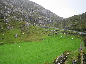
 R575 road
 | ||||
|---|---|---|---|---|
| Bóthar R575 | ||||
 R575 at Reentrusk, County Cork R575 at Reentrusk, County Cork | ||||
| Route information | ||||
| Length | 19.0 km (11.8 mi) | |||
| Major junctions | ||||
| From | ||||
| To | ||||
| Location | ||||
| Country | Ireland | |||
| Highway system | ||||
| ||||
The R575 road is a regional road in Ireland. It is a road on the Beara Peninsula in County Cork. The road forms part of the Wild Atlantic Way. Parts of the road form part of the Beara Way walking trail.
Hillsides by the road near Allihies are marked by ruins of former copper mines. The mines were at peak production in the 19th century but some were operational until 1962.
The R575 travels northeast from the R572 via Allihies and along the Kenmare River inlet. The road ends at the R571 near Eyeries. The R575 is 19.0 km (11.8 mi) long.
References
- ^ "R572 to R571" (Map). Google Maps. Retrieved 19 May 2016.
- ^ "S.I. No. 54/2012 – Roads Act 1993 (Classification of Regional Roads) Order 2012". Government of Ireland. 28 February 2012. Retrieved 19 May 2016.
- "Wild Atlantic Way: Explore The Route". Fáilte Ireland. Retrieved 19 May 2016.
- "The Beara Way". Ireland View. Retrieved 1 June 2016.
- ^ Poole, Susan; Gallagher, Lyn (2008). AA Best Drives Ireland. The Automobile Association. pp. 43–44. ISBN 978-0-7495-4430-0.
This geographical article about County Cork is a stub. You can help Misplaced Pages by expanding it. |
This Irish road or road transport-related article is a stub. You can help Misplaced Pages by expanding it. |