 R676 road
 | ||||
|---|---|---|---|---|
| Bóthar R676 | ||||
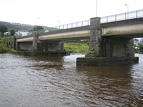
 Dillon Bridge carries the R676 over the River Suir in Carrick-on-Suir Dillon Bridge carries the R676 over the River Suir in Carrick-on-Suir | ||||
| Route information | ||||
| Length | 23.9 km (14.9 mi) | |||
| Major junctions | ||||
| From | ||||
| Major intersections |
| |||
| To | ||||
| Location | ||||
| Country | Ireland | |||
| Highway system | ||||
| ||||

The R676 road is a regional road in Ireland. It connects the N25 road in County Waterford to the N24 at Carrick-on-Suir, County Tipperary, via the villages of Mahon Bridge and Carrickbeg. The road is 23.9 kilometres (14.9 mi) long.
References
- ^ "N24 to N25" (Map). Google Maps. Retrieved 1 November 2020.
- ^ "S.I. No. 54/2012 – Roads Act 1993 (Classification of Regional Roads) Order 2012". Government of Ireland. 28 February 2012. Retrieved 1 November 2020.
This Irish road or road transport-related article is a stub. You can help Misplaced Pages by expanding it. |