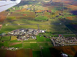
Airport in Blenheim, New Zealand
| RNZAF Base Woodbourne Tempered and Ready | |||||||||||||||||||
|---|---|---|---|---|---|---|---|---|---|---|---|---|---|---|---|---|---|---|---|
 | |||||||||||||||||||
| Summary | |||||||||||||||||||
| Airport type | Military/Civilian | ||||||||||||||||||
| Owner | New Zealand Defence Force | ||||||||||||||||||
| Operator | |||||||||||||||||||
| Serves | Blenheim, New Zealand | ||||||||||||||||||
| Location | Blenheim, New Zealand | ||||||||||||||||||
| Occupants |
| ||||||||||||||||||
| Elevation AMSL | 109 ft / 33 m | ||||||||||||||||||
| Coordinates | 41°31′06″S 173°52′13″E / 41.51833°S 173.87028°E / -41.51833; 173.87028 | ||||||||||||||||||
| Website | www | ||||||||||||||||||
| Map | |||||||||||||||||||
| Map showing RNZAF Base Woodbourne in red, and Woodbourne Airport in blue. | |||||||||||||||||||
| Runways | |||||||||||||||||||
| |||||||||||||||||||
RNZAF Base Woodbourne is a base of the Royal New Zealand Air Force, located 8 km west of Blenheim. Today, Woodbourne is the Air Force's only support base and has no operational squadrons based there. It shares its runways with the Blenheim civil airport, Woodbourne Airport.
History
Woodbourne was established in 1939 as the base for No. 2 Service Flying Training School (No.2 SFTS). Also located nearby during World War II were the ground training camps of the Delta. In 1942–43, No. 16 Squadron RNZAF and No. 18 Squadron RNZAF Squadrons flying Curtiss P-40 Warhawks used the satellite Fairhall field. In 1945 No.2 SFTS was closed and the Royal New Zealand Air Force Central Flying School and some ground training units, including the Officers' School of Instruction were relocated to Woodbourne. In 1949, The Aircraft Repair Depot RNZAF was relocated from Ohakea, and in 1951 the Boy Entrant School was established at Woodbourne.
The Ground Training Wing was created in 1995 from existing units at Woodbourne and those relocated from Wigram and Hobsonville, and is responsible for the training of recruits (General Service Training School), initial officer training (Command Training School), trade training (except aircrew, medical and photography training) and command training.
Woodbourne was the Air Force's only heavy maintenance facility for the repair of aircraft airframes, engines and avionics systems. This squadron was responsible for reconditioning airframes of RNZAF aircraft. It was known as the Airframe Reconditioning Squadron RNZAF. The unit was commercialised in 1998 and was managed by SAFE Air Ltd. In 2015 SAFE Air Ltd was purchased by Airbus and it continues to maintain military aircraft. SAFE Air Ltd formally relinquished the name and now trades under Airbus Asia Pacific. Airbus is currently finishing the last of the Air Force's C-130 Hercules airframe refurbishments. This will see the most highly houred C-130 Hercules (NZ7002) remain in flying service.
In 2024 the three local Māori iwi (tribes) entities Ngāti Apa ki te Rā Tō, Te Rūnanga o Ngāti Kuia and the Rangitāne o Wairau Settlement Trust decided to accept $25 million for a treaty settlement in view of the chemical contamination of the base's land. The compensation settlement was signed in early November 2024.
Units based at Woodbourne
Personnel strength is around 800.
- RNZAF Police
- RNZAF Rescue Fire
- NZDF Physical Training Instructors School
- RNZAF Security Forces
- RNZAF Logistics
- Base Medical
- Airbus
- Directorate of Defence Security
- Nelson Marlborough Institute of Technology Aeronautical Engineering programme
See also
References
- See Bryan E. Young, 'Beckoning Skies'
- Cambidgeairforce.org, The Marlborough Region
- "Kurahaupo iwi offered $25 million instead of Base Woodbourne land". Stuff. 2 September 2024.
- "$25m Treaty deal signed for contaminated RNZAF base land". Inside Government. JSL Media. 6 November 2024. Archived from the original on 11 November 2024. Retrieved 11 November 2024.
External links
| Units and squadrons |  | |
|---|---|---|
| Bases and facilities | ||
| Associated civil organisations | ||
| Equipment | ||
| Appointments | ||
| Symbols and uniform | ||
41°31′4.5″S 173°52′12″E / 41.517917°S 173.87000°E / -41.517917; 173.87000
This Marlborough Region-related geography article is a stub. You can help Misplaced Pages by expanding it. |
This military base or fortification article is a stub. You can help Misplaced Pages by expanding it. |