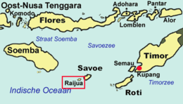
 Map of the islands of East Nusa Tenggara, including Raijua Map of the islands of East Nusa Tenggara, including Raijua | |
| Geography | |
|---|---|
| Archipelago | Sawu islands |
| Area | 36.08 km (13.93 sq mi) |
| Administration | |
| Indonesia | |
| Demographics | |
| Population | 9,679 (mid 2023 estimate ) |
| Pop. density | 268/km (694/sq mi) |
Raijua is an island in the Lesser Sunda Islands in Indonesia. Administratively it forms a district (kecamatan) of Sabu Raijua Regency wihin the province of East Nusa Tenggara. Its total land area is 13.9 square miles (36.08 square km), with a population of 9,679 in mid 2023. Raijua is sometimes called The Wedge by surfers because it includes an exposed reef break, making it an ideal surfing location during Indonesia's dry season (May through October).
References
- Badan Pusat Statistik, Jakarta, 26 September 2024, Kecamatan Raijua Dalam Angka 2024 (Katalog-BPS 1102001.5320010).
- "Encyclopædia Britannica: Raijua Island". Encyclopædia Britannica. Retrieved 3 July 2010.
- Badan Pusat Statistik, Jakarta, 26 September 2024, Kecamatan Raijua Dalam Angka 2024 (Katalog-BPS 1102001.5320010).
- "The Wedge (Raijua) Surf Forecast and Surf Reports (Timor, Indonesia)". Retrieved 3 July 2010.
10°37′11″S 121°34′24″E / 10.61972°S 121.57333°E / -10.61972; 121.57333
This East Nusa Tenggara location article is a stub. You can help Misplaced Pages by expanding it. |