| Ramat Raziel רמת רזיאל | |
|---|---|
 | |
 | |
| Coordinates: 31°46′26″N 35°4′22″E / 31.77389°N 35.07278°E / 31.77389; 35.07278 | |
| Country | Israel |
| District | Jerusalem |
| Council | Mateh Yehuda |
| Affiliation | Mishkei Herut Beitar |
| Founded | 1948 |
| Population | 659 |
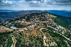
Ramat Raziel (Hebrew: רָמַת רָזִיאֵל, lit. 'Raziel Heights') is a moshav in central Israel. Located in the centre of the Jerusalem corridor, it falls under the jurisdiction of Mateh Yehuda Regional Council. In 2022 it had a population of 659.
History

The village was established in 1948 on land that had belonged to the depopulated Palestinian village of Kasla. It was named after David Raziel, chief commander of the Irgun.
Despite the difficult terrain, the economy was based on farming. In 1988 Eli Ben-Zaken planted vineyards and established Domaine du Castel, an award-winning winery, in Ramat Raziel.
References
- ^ "Regional Statistics". Israel Central Bureau of Statistics. Retrieved 21 March 2024.
- Khalidi, Walid (1992). All That Remains: The Palestinian Villages Occupied and Depopulated by Israel in 1948. Washington D.C.: Institute for Palestine Studies. p. 299. ISBN 0-88728-224-5.
- David Raziel
- David Raziel Jewish Virtual Library
- Ramat Raziel
- Castel: Wine and the wonder of Israel The Jerusalem Post