Unincorporated community in California, United States
| Red Mountain, California | |
|---|---|
| Unincorporated community | |
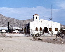
 An abandoned church in Red Mountain An abandoned church in Red Mountain | |
  | |
| Coordinates: 35°21′30″N 117°37′00″W / 35.35833°N 117.61667°W / 35.35833; -117.61667 | |
| Country | United States |
| State | California |
| County | San Bernardino |
| Elevation | 3,401 ft (1,037 m) |
| Population | |
| • Total | 131 |
| Time zone | UTC-8 (Pacific (PST)) |
| • Summer (DST) | UTC-7 (PDT) |
| ZIP code | 93558 |
| Area codes | 442/760 |
| GNIS feature ID | 1661291 |
Red Mountain, formerly known as Osdick, is an unincorporated community in San Bernardino County, California, United States.
Red Mountain was established in 1919 as Osdick, a silver mine boom town Red Mountain is 32 miles (51 km) south-southwest of Trona, part of the mining district of Randsburg, California and Johannesburg, California.
Red Mountain has a post office with ZIP code 93558. The post office opened under the name Osdick in 1922 and changed its name to Red Mountain in 1929.
In 2022, the community received a $1.5 million grant to clean sediment of arsenic from historic gold and silver mining from the kelly mine complex.
References
- ^ "Red Mountain Mining Town".
- "US Board on Geographic Names". United States Geological Survey. October 25, 2007. Retrieved January 31, 2008.
- "29_North_Desert_CAG_2020.pdf" (PDF). San Bernardino County.
- "Free ZIP Code Lookup with area code, county, geocode, MSA/PMSA, population".
- Durham, David L. (1998). California's Geographic Names: A Gazetteer of Historic and Modern Names of the State. Quill Driver Books. p. 1460. ISBN 1-884995-14-4.
- "Historic mining town plagued by arsenic gets federal funds for cleanup effort". San Bernardino Sun. November 27, 2022. Retrieved November 29, 2022.
This San Bernardino County, California–related article is a stub. You can help Misplaced Pages by expanding it. |
