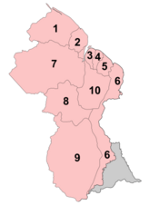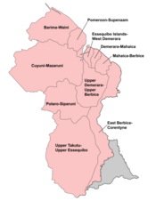
 Regions of Guyana by number and name
Guyana is divided into 10 regions:
| No. | Region | Area (km) |
Pop. (2012) |
Pop. per km |
Capital |
|---|---|---|---|---|---|
| 1 | Barima-Waini | 20,339 | 26,941 | 1.3 | Mabaruma |
| 2 | Pomeroon-Supenaam | 6,195 | 46,810 | 7.6 | Anna Regina |
| 3 | Essequibo Islands-West Demerara | 3,755 | 107,416 | 28.6 | Vreed en Hoop |
| 4 | Demerara-Mahaica | 2,232 | 313,429 | 140.4 | Triumph |
| 5 | Mahaica-Berbice | 4,190 | 49,723 | 11.9 | Fort Wellington |
| 6 | East Berbice-Corentyne | 36,234 | 109,431 | 3.0 | New Amsterdam |
| 7 | Cuyuni-Mazaruni | 47,213 | 20,280 | 0.4 | Bartica |
| 8 | Potaro-Siparuni | 20,051 | 10,190 | 0.5 | Mahdia |
| 9 | Upper Takutu-Upper Essequibo | 57,750 | 24,212 | 0.4 | Lethem |
| 10 | Upper Demerara-Berbice | 17,040 | 39,452 | 2.3 | Linden |
| Guyana | 214,999 | 747,884 | 3.5 | Georgetown |
Each Region is administered by a Regional Democratic Council (RDC) which is headed by a Chairman. The Regions are divided into neighbourhood councils, known as Neighbourhood Democratic Councils (NDCs).
The current regional structure was established by the Local Democratic Organs Act in 1980. The hyphenated names indicate the name of the rivers that define their border.
Historical divisions
Previous regional names:
Regions of Guyana (1971)
- East Berbice-Corentyne
- East Demerara-West Coast Berbice
- Mazaruni Potaro
- North West
- Rupununi
- West Demerara-Essequibo Coast
Regions of British Guiana (1958)
- East Berbice
- Essequibo
- Essequibo Islands
- North west (hinterlands)
- Mazaruni-Potaro (hinterlands)
- Rupununi (hinterlands)
Colonial counties (before 1958)
See also
- ISO 3166-2:GY
- List of Caribbean First-level Subdivisions by Total Area
- List of Guyanese regions by Human Development Index
References
- Bureau of Statistics - Guyana Archived 2012-02-17 at the Wayback Machine, CHAPTER III: POPULATION REDISTRIBUTION AND INTERNAL MIGRATION, Table 3.4: Population Density, Guyana: 1980 - 2002
- Guyana - Government Information Agency Archived 2007-08-14 at the Wayback Machine, National Profile
- "Region Four RDC office moves to Triumph". Stabroek News. Retrieved 18 August 2020.
- "Regional Democratic Council Region No. 4 - Demerara/Mahaica, Guyana". Regional Democratic Council Region No. 4via Facebook. Retrieved 18 August 2020.
- Government of Guyana, Statistics
- "THE LOCAL DEMOCRATIC ORGANS ACT 1980" (PDF). parliament.gov.g. 7 October 1980. Retrieved 2020-01-03.
- "Internal Administrative Divisions of British Guiana" (PDF). Cia.gov. 29 August 1958. Archived from the original (PDF) on January 22, 2017. Retrieved 2020-01-03.
- "ADMIN REGIONS DETAILED – GUYANA LANDS AND SURVEYS COMMISSION'S FACT PAGE ON GUYANA". Retrieved 2021-03-16.
External links
- "Regions of Guyana". Statoids.
| Regions of Guyana | ||
|---|---|---|
| First-level administrative divisions of South American countries | |
|---|---|
| Table of administrative country subdivisions by country |