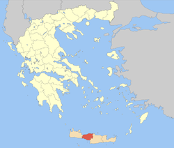
| Rethymno
Περιφερειακή ενότητα Ρεθύμνου | |
|---|---|
| Regional unit | |
 Municipalities of Rethymno Municipalities of Rethymno | |
  | |
| Coordinates: 35°15′N 24°35′E / 35.250°N 24.583°E / 35.250; 24.583 | |
| Country | Greece |
| Administrative region | Crete |
| Seat | Rethymno |
| Area | |
| • Total | 1,496 km (578 sq mi) |
| Population | |
| • Total | 84,866 |
| • Density | 57/km (150/sq mi) |
| Time zone | UTC+2 (EET) |
| • Summer (DST) | UTC+3 (EEST) |
| Postal code | 74x xx |
| Area code(s) | 283x0 |
| Vehicle registration | ΡΕ |
| Website | www |
Rethymno (Greek: Περιφερειακή ενότητα Ρεθύμνου) is one of the four regional units of Crete, Greece. Its capital is the city of Rethymno. Today its main income is tourism. The countryside is also based economically on agriculture and herding.
Administration
The regional unit Rethymno is subdivided into five municipalities. These are (number as in the map in the infobox):
- Agios Vasileios (2)
- Amari (3)
- Anogeia (4)
- Mylopotamos (5)
- Rethymno (1)
Prefecture
The Rethymno prefecture (Greek: Νομός Ρεθύμνου or Ρεθύμνης) was created while Crete was still an autonomous state, and was preserved after the island joined Greece in 1913. As a part of the 2011 Kallikratis government reform, the Rethymno regional unit was created out of the former prefecture. The prefecture had the same territory as the present regional unit. At the same time, the municipalities were reorganised, according to the table below.
| New municipality | Old municipalities | Seat |
|---|---|---|
| Agios Vasileios | Lampi | Spili |
| Foinikas | ||
| Amari | Kourites | Agia Foteini |
| Sivritos | ||
| Anogeia | Anogeia | Anogeia |
| Mylopotamos | Geropotamos | Perama |
| Kouloukonas | ||
| Zoniana | ||
| Rethymno | Rethymno | Rethymno |
| Arkadi | ||
| Lappa | ||
| Nikiforos Fokas |
Provinces
- Rethymno Province - Rethymno
- Agios Vasileios Province - Spili
- Amari Province - Amari
- Mylopotamos Province - Perama
Note: Provinces no longer hold any legal status in Greece.
Main towns
The main towns of the regional unit Rethymno are (ranked by 2021 census population):
- Rethymno 34,085
- Violi Charaki 3,185
- Anogeia 2,201
Notable people
See also
References
- "Αποτελέσματα Απογραφής Πληθυσμού - Κατοικιών 2021, Μόνιμος Πληθυσμός κατά οικισμό" [Results of the 2021 Population - Housing Census, Permanent population by settlement] (in Greek). Hellenic Statistical Authority. 29 March 2024.
- ^ "ΦΕΚ A 87/2010, Kallikratis reform law text" (in Greek). Government Gazette.
| Administrative division of the Crete Region | ||
|---|---|---|
| Regional unit of Chania |  | |
| Regional unit of Heraklion | ||
| Regional unit of Lasithi | ||
| Regional unit of Rethymno | ||
| ||