Human settlement in Wales
| Rhyd-uchaf | |
|---|---|
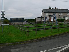
 Cae Gwyn, Rhyd-uchaf Cae Gwyn, Rhyd-uchaf | |
 | |
| Population | 78 (2011) |
| OS grid reference | SH900378 |
| • Cardiff | 143.3 miles |
| Community | |
| Principal area | |
| Country | Wales |
| Sovereign state | United Kingdom |
| Post town | BALA |
| Postcode district | LL23 |
| Dialling code | 01678 |
| Police | North Wales |
| Fire | North Wales |
| Ambulance | Welsh |
| UK Parliament | |
| Senedd Cymru – Welsh Parliament | |
| 52°55′38″N 3°38′16″W / 52.927086°N 3.637794°W / 52.927086; -3.637794 | |
Rhyd-uchaf is a hamlet in Gwynedd, Wales, approximately 2.4 miles (3.9 km) northwest of Bala and 1.4 miles (2.3 km) south of Frongoch (by footpath), on an unnamed road which provides access to Arenig Fawr. The community population taken at the 2011 census was 78.
Talybont Chapel
Talybont Chapel was built in 1837, with services held on behalf of the Presbyterian Church of Wales.
Governance
Rhyd-uchaf is within the electoral ward of Llandderfel and the parish of Llanycil.
References
- "Direction: Rhyd-uchaf, Gwynedd to Frongoch, Bala". Google Maps. Google. Retrieved 12 April 2016.
- "community population 2011". Retrieved 16 May 2015.
- "Presbyterian Church of Wales".
This Gwynedd location article is a stub. You can help Misplaced Pages by expanding it. |
