| This article needs additional citations for verification. Please help improve this article by adding citations to reliable sources. Unsourced material may be challenged and removed. Find sources: "Ridala Parish" – news · newspapers · books · scholar · JSTOR (February 2022) (Learn how and when to remove this message) |
| Ridala Parish Ridala vald | |
|---|---|
| Former municipality of Estonia | |
 Ungru Castle ruins Ungru Castle ruins | |
 Flag Flag Coat of arms Coat of arms | |
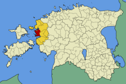
 Ridala Parish within Lääne County. Ridala Parish within Lääne County. | |
| Country | |
| County | |
| Administrative centre | Uuemõisa |
| Area | |
| • Total | 253.4 km (97.8 sq mi) |
| Population | |
| • Total | 3,245 |
| • Density | 13/km (33/sq mi) |
| Website | http://www.ridala.ee |
Ridala (Estonian: Ridala vald) was a rural municipality of Estonia, in Lääne County. It had a population of 3,245 (2016) and an area of 253.4 km (157.5 mi).
In 2007 it was merged with the city of Haapsalu to establish the Haapsalu urban municipality.
Part of the parish is within the Matsalu National Park.
Populated places
Ridala Parish had two small boroughs and 56 villages.
- Small boroughs
- Villages
Aamse, Allika, Ammuta, Emmuvere, Erja, Espre, Haeska, Herjava, Hobulaiu, Jõõdre, Kabrametsa, Kadaka, Kaevere, Kiideva, Kiltsi, Kiviküla, Koheri, Koidu, Kolila, Kolu, Käpla, Laheva, Lannuste, Liivaküla, Litu, Lõbe, Metsaküla, Mäeküla, Mägari, Nõmme, Panga, Parila, Puiatu, Puise, Pusku, Põgari-Sassi, Rohense, Rohuküla, Rummu, Saanika, Saardu, Sepaküla, Sinalepa, Suure-Ahli, Tammiku, Tanska, Tuuru, Uneste, Uuemõisa, Valgevälja, Varni, Vilkla, Võnnu, Väike-Ahli, Vätse, Üsse.
See also
References
- "X-GIS(3) Portal". xgis.maaamet.ee. Retrieved 3 February 2022.
58°56′35″N 23°38′42″E / 58.94306°N 23.64500°E / 58.94306; 23.64500
This Lääne County location article is a stub. You can help Misplaced Pages by expanding it. |