Unincorporated community in Kentucky, United States
| River, Kentucky | |
|---|---|
| Unincorporated community | |
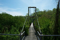
 The Forrest and Maxie Preston Memorial Bridge The Forrest and Maxie Preston Memorial Bridge | |
  | |
| Coordinates: 37°51′39.57″N 82°43′34.43″W / 37.8609917°N 82.7262306°W / 37.8609917; -82.7262306 | |
| Country | United States |
| State | Kentucky |
| County | Johnson |
| Elevation | 633 ft (193 m) |
| Time zone | UTC-5 (Eastern (EST)) |
| • Summer (DST) | UTC-5 (EDT) |
| ZIP code | 41254 |
| Area code | 606 |
| GNIS feature ID | 501977 |
River is an unincorporated community in Johnson County, Kentucky, United States. The post office was first established on September 6, 1890, and its current ZIP code is 41254. Its telephone area code is 606. Its geographic coordinates are (37.86102 N, 82.72623 W).
History
A post office called River has been in operation since 1890. The community took its name from the nearby river.
Trivia
In 1999, the community of River received international attention for having the world's longest "plastic" bridge. The wooden deck of the 420-foot-long (130 m) Forrest and Maxie Preston Memorial Bridge was replaced with a deck made of glass fiber-reinforced polymer composites. The bridge is 30 feet longer than Aberfeldy Bridge in Scotland, which was the former recordholder. The bridge spans the Levisa Fork and connects River to the community of Offutt.
River is also noted as the birthplace of country music star Hylo Brown and is the burial site of legendary pioneer, Jenny Wiley.
Nearby cities and towns
- Beauty, Kentucky (9.4 miles)
- Boonscamp, Kentucky (4.0 miles)
- Crum, West Virginia (10.8 miles)
- Debord, Kentucky (7.0 miles)
- Inez, Kentucky (7.1 miles)
- Lowmansville, Kentucky (8.9 miles)
- Meally, Kentucky (7.2 miles)
- Paintsville, Kentucky (5.8 miles)
- Pilgrim, Kentucky (12.4 miles)
- Stambaugh, Kentucky (8.9 miles)
- Thelma, Kentucky (7.7 miles)
- Tomahawk, Kentucky (1.9 miles)
- Tutor Key, Kentucky (6.4 miles)
- Ulysses, Kentucky (6.1 miles)
- Van Lear, Kentucky (9.0 miles)
- West Van Lear, Kentucky (9.9 miles)
- Williamsport, Kentucky (5.9 miles)
References
- U.S. Geological Survey Geographic Names Information System: River, Kentucky
- Rennick, Robert M. (1988). "Place Names". Kentucky Place Names. Lexington, Kentucky: The University Press of Kentucky. ISBN 0-8131-0179-4.Retrieved on 2009-08-29
- ZIP Code Look-up Retrieved 2009-11-28
- "Johnson County". Jim Forte Postal History. Retrieved December 24, 2015.
- Rennick, Robert M. Kentucky Place Names. University Press of Kentucky. p. 252. ISBN 0-8131-2631-2.
- Forrest and Maxie Preston Memorial Bridge Retrieved on 2009-08-29
External links
- Forrest and Maxie Preston Memorial Bridge
- River, KY info at hometownlocator.com website
- Black Barn Produce, LLC
| Municipalities and communities of Johnson County, Kentucky, United States | ||
|---|---|---|
| County seat: Paintsville | ||
| City |  | |
| CDPs | ||
| Other unincorporated communities |
| |