| River Des Peres Park | |
|---|---|
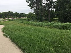
 River des Peres Park, June 2018 River des Peres Park, June 2018 | |
| Type | Urban Park |
| Location | St. Louis, Missouri, United states |
| Coordinates | 38°34′59″N 90°18′43″W / 38.5830°N 90.3120°W / 38.5830; -90.3120 |
| Area | 145 acres (59 ha) |
| Created | 1934 |
| Operated by | St. Louis Department of Parks, Recreation, and Forestry |
| Status | Open |
| Public transit access | |
| Website | http://stlouis-mo.gov |
River Des Peres Park is a municipal park in St. Louis that opened in 1934. River Des Peres Park is located near River Des Peres and the St. Louis City/County border line. The parks borders are Lansdowne Avenue, Morganford Avenue, and River Des Peres Boulevard. It is located near the neighborhoods of St. Louis Hills, Lindenwood Park, and Princeton Heights.
See also
External links
- Parks of St. Louis - St. Louis Parks Department website
| Parks in Greater St. Louis | |||||||||
|---|---|---|---|---|---|---|---|---|---|
| St. Louis City parks | |||||||||
| St. Louis County parks |
| ||||||||
| St. Charles County parks |
| ||||||||
| Jefferson County parks |
| ||||||||
| Lincoln County parks |
| ||||||||
| Metro East (Illinois) |
| ||||||||
This St. Louis location article is a stub. You can help Misplaced Pages by expanding it. |