Suburb of Perth, Western Australia
| Rivervale Perth, Western Australia | |||||||||||||||
|---|---|---|---|---|---|---|---|---|---|---|---|---|---|---|---|
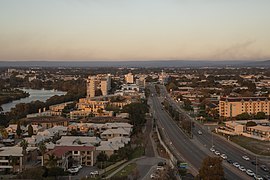
 Rivervale from the Aloft Hotel Rivervale from the Aloft Hotel | |||||||||||||||
| Coordinates | 31°57′40″S 115°55′01″E / 31.961°S 115.917°E / -31.961; 115.917 | ||||||||||||||
| Population | 10,897 (SAL 2021) | ||||||||||||||
| Established | 1843 | ||||||||||||||
| Postcode(s) | 6103 | ||||||||||||||
| Area | 3.0 km (1.2 sq mi) | ||||||||||||||
| Location | 5 km (3 mi) from Perth | ||||||||||||||
| LGA(s) | City of Belmont | ||||||||||||||
| State electorate(s) | Belmont | ||||||||||||||
| Federal division(s) | Swan | ||||||||||||||
| |||||||||||||||
Rivervale is an inner eastern suburb of Perth, Western Australia. It is near the Swan River, 5 kilometres (3 mi) from the Perth central business district, and within the City of Belmont.
Rivervale was known as Barndon Hill until 1884.
Transport
Bus
- 51 Perth Busport to Cannington Station – serves Orrong Road
- 270 Elizabeth Quay Bus Station to High Wycombe Station – serves Great Eastern Highway and Belmont Avenue
- 935 (previously known as the 37) Kings Park to Redcliffe Station (high frequency) – serves Great Eastern Highway, Kooyong Road, Alexander Road and Belmont Avenue
- 940 Elizabeth Quay Bus Station to Redcliffe Station (high frequency) – serves Great Eastern Highway
References
- Australian Bureau of Statistics (28 June 2022). "Rivervale (suburb and locality)". Australian Census 2021 QuickStats. Retrieved 28 June 2022.

- ^ "A history of Rivervale" (PDF). City of Belmont. Retrieved 4 March 2024.
- "History of metropolitan suburb names – R". Western Australian Land Information Authority. Archived from the original on 16 March 2022. Retrieved 4 August 2008.
- "Suburb Profile - Rivervale". Finbar. 2019. Retrieved 4 March 2024.
- "Route 51". Bus Timetable 88 (PDF). Transperth. 13 August 2024 .
- "Route 270". Bus Timetable 108 (PDF). Transperth. 8 October 2024 .
- "Route 935". Bus Timetable 209 (PDF). Transperth. 14 October 2024 .
- "Route 940". Bus Timetable 214 (PDF). Transperth. 11 October 2024 .
| Suburbs of the City of Belmont, Perth, Western Australia | |
|---|---|
This Perth location article is a stub. You can help Misplaced Pages by expanding it. |