| Treaty | Treaty 4 |
|---|---|
| Headquarters | Erickson, Manitoba |
| Land | |
| Main reserve | Rolling River 67 |
| Other reserve(s) |
|
| Population (2021) | |
| On reserve | 348 |
| On other land | 5 |
| Off reserve | 765 |
| Total population | 1118 |
| Tribal Council | |
| West Region Tribal Council | |
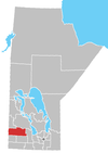
The Rolling River First Nation (Ojibwe: Ditibineya-ziibiing) is an Ojibwe First Nations community in Manitoba, located south of Riding Mountain National Park.
About half of the members are resident on its reserves, which are located south and east of Erickson, Manitoba.
Reserve lands
Rolling River First Nation is in possession of three reserves:
- Rolling River 67 (50°27′28″N 99°59′32″W / 50.45778°N 99.99222°W / 50.45778; -99.99222) — the main reserve, with a total size of 6,776.10 ha (16,744.1 acres). It is located 64 km (40 mi) north of Brandon. Bordered mostly by the RM of Harrison, it also has a significant border with the RM of Clanwilliam, as well as a much smaller border with the RM of Minto.
- Rolling River 67A (50°38′27″N 99°51′27″W / 50.64083°N 99.85750°W / 50.64083; -99.85750) — has a total size of 1,017.60 ha (2,514.5 acres)
- Rolling River 67B (50°27′55″N 99°54′48″W / 50.46528°N 99.91333°W / 50.46528; -99.91333) — has a total size of 297.10 ha (734.2 acres)
- Rolling River 67C (49°53′10″N 97°20′40″W / 49.88611°N 97.34444°W / 49.88611; -97.34444) — has a total size of 31.40 ha (77.6 acres)
- Treaty Four Reserve Grounds 77 — a reserve shared with several other First Nations; it has a total size of 99.20 ha (245.1 acres)
External links
References
- "Home". Crown–Indigenous Relations and Northern Affairs Canada. Government of Canada. 3 November 2008.
- Andy Thomas Thomas, Florence Paynter. The Significance of Creating First Nation Traditional Names Maps. Manitoba First Nations Education Resource Centre Inc. https://mfnerc.org/wp-content/uploads/2015/05/The-Significance-of-Creating-First-Nation-Traditional-Names-Maps.pdf
- Parks Canada Agency, Government of Canada (2020-04-30). "Rolling River - Riding Mountain National Park". www.pc.gc.ca. Retrieved 2021-08-18.
- Indigenous and Northern Affairs Canada (2019-04-09). "Rolling River | Reserves/Settlements/Villages". Crown–Indigenous Relations and Northern Affairs Canada. Government of Canada. Retrieved 2021-08-18.
| Division No. 15, Manitoba (Western Manitoba) | ||||
|---|---|---|---|---|
| Towns |
|  | ||
| Villages |
| |||
| Rural municipalities |
| |||
| First Nations | ||||
| Indian reserves | ||||
| Unincorporated communities | ||||
50°27′41″N 99°59′56″W / 50.46139°N 99.99889°W / 50.46139; -99.99889
This First Nations in Canada–related article is a stub. You can help Misplaced Pages by expanding it. |
This Manitoba location article is a stub. You can help Misplaced Pages by expanding it. |