| This article includes a list of references, related reading, or external links, but its sources remain unclear because it lacks inline citations. Please help improve this article by introducing more precise citations. (May 2013) (Learn how and when to remove this message) |
| Rosdorf | |
|---|---|
| Municipality | |
 Coat of arms Coat of arms | |
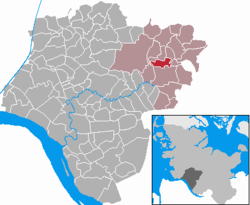
Location of Rosdorf within Steinburg district
 | |
  | |
| Coordinates: 53°58′N 9°43′E / 53.967°N 9.717°E / 53.967; 9.717 | |
| Country | Germany |
| State | Schleswig-Holstein |
| District | Steinburg |
| Municipal assoc. | Kellinghusen |
| Government | |
| • Mayor | Hauke Vollstedt |
| Area | |
| • Total | 5.6 km (2.2 sq mi) |
| Elevation | 3 m (10 ft) |
| Population | |
| • Total | 370 |
| • Density | 66/km (170/sq mi) |
| Time zone | UTC+01:00 (CET) |
| • Summer (DST) | UTC+02:00 (CEST) |
| Postal codes | 25548 |
| Dialling codes | 04822 |
| Vehicle registration | IZ |
| Website | www.kellinghusen.de |
Rosdorf is a municipality in the district of Steinburg, in Schleswig-Holstein, Germany. It is located around 3 kilometres north of Kellinghusen and east of the Stör River. Rosdorf is situated in the Aukrug Nature Park. The federal highway Bundesstraße 206 from Lübeck to Itzehoe is about 4 kilometres south of Rosdorf.
References
- "Bevölkerung der Gemeinden in Schleswig-Holstein 4. Quartal 2022" (XLS) (in German). Statistisches Amt für Hamburg und Schleswig-Holstein.
This Steinburg location article is a stub. You can help Misplaced Pages by expanding it. |