| Rose Lake | |
|---|---|
 | |
  | |
| Location | Cook County, Minnesota, and Ontario. |
| Coordinates | 48°06′04″N 90°25′34″W / 48.101°N 90.426°W / 48.101; -90.426 |
| Primary inflows | Duncan Lake, Daniels Lake, Rat Lake, Rove Lake |
| Primary outflows | Arrow River |
| Basin countries | United States, Canada |
| Surface area | 1,315 acres (5 km) |
| Max. depth | 90 ft (27 m) |
| Surface elevation | 1,528 ft (466 m) |
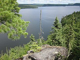
Rose Lake is a lake on the border between Cook County, Minnesota and Ontario.
Topography
Rose Lake covers a surface of 1315 acres and has a maximum depth of 90 feet. It rests in the Rove Formation, which is characterized by Animikie slates interrupted by diabase sills which form long, parallel, east-west ridges with shallow south rises and steep cliffs on the north. The ridge to the south of Rose Lake rises three hundred feet over the lake's surface for nearly all its length. Rose Lake Mountain, on the ridge to the south, was originally surveyed at 1997 feet above sea level. Rose sits at 1528 feet above sea level, and being the lowest surface water in the Rove Formation, drains the nearby Duncan Lake, South Lake, and Watap Lake. It empties into the Arrow River, a tributary of the Pigeon River, which ultimately drains into Lake Superior.
Climate
Rose Falls is a waterfall that flows into Rose Lake from Duncan Lake. There is no weather station, but this climate table contains interpolated data. Rose Falls has a humid continental climate (Köppen Dfb), closely bordering on a subarctic climate (Köppen Dfc).
| Climate data for Rose Falls 48.0923 N, 90.4358 W, Elevation: 1,736 ft (529 m) (1991–2020 normals) | |||||||||||||
|---|---|---|---|---|---|---|---|---|---|---|---|---|---|
| Month | Jan | Feb | Mar | Apr | May | Jun | Jul | Aug | Sep | Oct | Nov | Dec | Year |
| Mean daily maximum °F (°C) | 13.6 (−10.2) |
19.9 (−6.7) |
33.1 (0.6) |
44.8 (7.1) |
59.8 (15.4) |
69.9 (21.1) |
74.8 (23.8) |
74.0 (23.3) |
64.2 (17.9) |
47.5 (8.6) |
32.5 (0.3) |
19.3 (−7.1) |
46.1 (7.8) |
| Daily mean °F (°C) | 2.6 (−16.3) |
7.5 (−13.6) |
19.8 (−6.8) |
33.5 (0.8) |
48.3 (9.1) |
58.7 (14.8) |
63.9 (17.7) |
62.1 (16.7) |
53.8 (12.1) |
38.9 (3.8) |
23.7 (−4.6) |
10.0 (−12.2) |
35.2 (1.8) |
| Mean daily minimum °F (°C) | −8.5 (−22.5) |
−5.0 (−20.6) |
6.5 (−14.2) |
22.1 (−5.5) |
36.8 (2.7) |
47.6 (8.7) |
53.1 (11.7) |
50.2 (10.1) |
43.5 (6.4) |
30.4 (−0.9) |
15.0 (−9.4) |
0.7 (−17.4) |
24.4 (−4.2) |
| Average precipitation inches (mm) | 1.32 (34) |
1.11 (28) |
1.23 (31) |
2.15 (55) |
3.09 (78) |
3.90 (99) |
3.94 (100) |
3.11 (79) |
3.41 (87) |
2.91 (74) |
1.96 (50) |
1.68 (43) |
29.81 (758) |
| Source: PRISM Climate Group | |||||||||||||
Plant and Animal Life
Rose Lake contains Walleye, Lake Trout, Smallmouth Bass, Cisco, Lake Whitefish, Rainbow Smelt, Burbot, Yellow Perch, and White Sucker. It sits in a forest dominated by white pines and cedars.
Human Use
Rose Lake became the terminus of the Alger Smith railroad after the General Logging Company purchased its northern portion and extended it from Two Island Lake in the 1920s. Logging reached the eastern shore of Rose Lake around 1929, but ended shortly thereafter when the General Logging Company suffered setbacks due to the Brule Lake Fire of 1929 and the onset of the Great Depression. In 1936, a forest fire began in Ontario and crossed the international border at the lake, but was contained by the firefighting crews of the Superior National Forest.
Rose Lake is in the Boundary Waters Canoe Area within the USA and the Crownland of Ontario Canada. The BWCA restricts access to specific entry points. Rose Lake may be accessed by canoe through a portage from Duncan Lake, or by foot through the Border Route Trail or Caribou Rock Trail.
References
- ^ Rose Lake information report, Minnesota Department of Natural Resources, 2013. Retrieved August 19, 2013.
- ^ Grant, Ulysses S. II, "The Geology of the Rove Lake Plate," The Geology of Minnesota, Vol. 6. Ed. N. H. Winchell. p. 492. The Pioneer Press Printers, St. Paul, 1899.
- File:Geologic map NE Minnesota.jpg
- Grant, Ulysses S. II, "The Geology of the Rove Lake Plate," The Geology of Minnesota, Vol. 6. Ed. N. H. Winchell. p. 493. The Pioneer Press Printers, St. Paul, 1899.
- "PRISM Climate Group, Oregon State University". PRISM Climate Group, Oregon State University. Retrieved October 30, 2023.
To find the table data on the PRISM website, start by clicking Coordinates (under Location); copy Latitude and Longitude figures from top of table; click Zoom to location; click Precipitation, Minimum temp, Mean temp, Maximum temp; click 30-year normals, 1991-2020; click 800m; click Retrieve Time Series button.
- Diebel, Lynne Smith, Paddling Northern Minnesota. p. 142. Sheridan Books, USA, 2005.
- ^ Heinselman, Miron L. Boundary Waters Wilderness Ecosystem. p. 107. University of Minnesota Press, 1996.
- Heinselman, Miron L. Boundary Waters Wilderness Ecosystem. p. 154. University of Minnesota Press, 1996.
- Diebel, Lynne Smith, Paddling Northern Minnesota. p. 143. Sheridan Books, USA, 2005.