| Rousínov | |
|---|---|
| Town | |
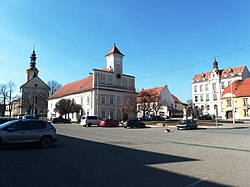
 Sušilovo Square with Old Town Hall and Sušilovo Square with Old Town Hall andChurch of Saint Mary Magdalene | |
 Flag Flag Coat of arms Coat of arms | |
 | |
| Coordinates: 49°12′5″N 16°52′56″E / 49.20139°N 16.88222°E / 49.20139; 16.88222 | |
| Country | |
| Region | South Moravian |
| District | Vyškov |
| First mentioned | 1222 |
| Government | |
| • Mayor | Jiří Lukášek |
| Area | |
| • Total | 23.05 km (8.90 sq mi) |
| Elevation | 240 m (790 ft) |
| Population | |
| • Total | 5,962 |
| • Density | 260/km (670/sq mi) |
| Time zone | UTC+1 (CET) |
| • Summer (DST) | UTC+2 (CEST) |
| Postal code | 683 01 |
| Website | www |
Rousínov (until 1921 Nový Rousínov; German: Neu Raußnitz, Neuraussnitz) is a town in Vyškov District in the South Moravian Region of the Czech Republic. It has about 6,000 inhabitants.
Administrative parts
The villages of Čechyně, Královopolské Vážany, Kroužek, Rousínovec, Slavíkovice and Vítovice are administrative parts of Rousínov.
Geography
Rousínov is located about 11 kilometres (7 mi) southwest of Vyškov and 15 km (9 mi) east of Brno. It lies mostly in the Vyškov Gate, only the southern part of the municipal territory lies in the Litenčice Hills. The Rakovec Stream flows through the town.
History
The first written mention of Rousínov is from 1222. In 1321, it was last referred to as a village. It belonged to the Špilberk estate. It became an important crossroads of trade routes from Vienna and from Olomouc. Rousínov was a royal town until 1559, when Ferdinand I sold the Špilberk estate.
The Jewish community existed here from the second half of the 15th century until 1919. The business activities of the Jews after the Thirty Years' War brought economic prosperity to the town.
Until 1945, the village of Čechyně belonged to the German-speaking enclave called Vyškov Language Island. The area was colonized by German settlers in the second half of the 13th century. The coexistence of Czechs and Germans was mostly peaceful, which changed only after 1935, when many Germans tended to Nazism. In 1945, the German population was expelled.
Demographics
|
|
| ||||||||||||||||||||||||||||||||||||||||||||||||||||||
| Source: Censuses | ||||||||||||||||||||||||||||||||||||||||||||||||||||||||
Transport

The D1 motorway from Brno to Ostrava runs around the town.
Rousínov is located on the railway line Brno–Olomouc.
Sights

The main landmark of Rousínov is the Church of Saint Mary Magdalene. It was built in the Baroque style at the turn of the 17th and 18th centuries, according to the design by Domenico Martinelli.
In addition to the church, the landmark of the town square is the Old Town Hall building. It is a valuable Baroque building from the first half of the 18th century.
The former synagogue was built in the Neoclassical style in 1842 on the site of an older synagogue. Today the building is used as the prayer house of the Czechoslovak Hussite Church.
The Church of Saint Wenceslaus is located in Rousínovec. It was built in the Baroque style in 1718–1734 and also was designed by D. Martinelli.
The Church of Saints Philip and James is located in Královopolské Vážany. It was built in the late Baroque style in 1763–1768. Next to the church is a separate Neoclassical bell tower, dating from 1828.
Notable people
- Menahem Mendel Auerbach (1620–1689), Austrian rabbi, banker, and commentator; lived here
- Josef Flesch (1781–1839), writer and translator
- Nikolai Brashman (1796–1866), Russian mathematician
- František Sušil (1804–1868), priest and folk music collector
- Nehemiah Brüll (1843–1892), rabbi
Twin towns – sister cities
See also: List of twin towns and sister cities in the Czech RepublicRousínov is twinned with:
 Dervio, Italy
 Halásztelek, Hungary
 Podbranč, Slovakia
References
- "Population of Municipalities – 1 January 2024". Czech Statistical Office. 2024-05-17.
- ^ "Historie" (in Czech). Město Rousínov. Retrieved 2021-11-30.
- "S památníkem německým starousedlíkům si Vyškov zatím neví rady" (in Czech). iDNES.cz. 2012-03-05. Retrieved 2022-01-12.
- "Historický lexikon obcí České republiky 1869–2011" (in Czech). Czech Statistical Office. 2015-12-21.
- "Population Census 2021: Population by sex". Public Database. Czech Statistical Office. 2021-03-27.
- "Detail stanice Rousínov" (in Czech). České dráhy. Retrieved 2024-05-24.
- "Kostel sv. Maří Magdalény" (in Czech). National Heritage Institute. Retrieved 2024-05-24.
- "Radnice" (in Czech). National Heritage Institute. Retrieved 2024-05-24.
- "Synagoga" (in Czech). National Heritage Institute. Retrieved 2024-05-24.
- "Kostel sv. Václava" (in Czech). National Heritage Institute. Retrieved 2024-05-24.
- "Areál kostela sv. Filipa a Jakuba" (in Czech). National Heritage Institute. Retrieved 2024-05-24.
- "Zvonice" (in Czech). National Heritage Institute. Retrieved 2024-05-24.
- "Partnerská města" (in Czech). Město Rousínov. Retrieved 2021-11-30.
External links
- Official website
- History of Rousínov Jews on zidi-rousinov.webnode.cz