You can help expand this article with text translated from the corresponding article in Hebrew. (October 2023) Click for important translation instructions.
|
 Route 541
 | ||||
|---|---|---|---|---|
| כביש 541 | ||||
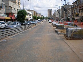
 Route 541 in the center of Herzliya, during construction to turn it into a Pedestrian zone Route 541 in the center of Herzliya, during construction to turn it into a Pedestrian zone | ||||
| Route information | ||||
| Length | 10.26 km (6.38 mi) | |||
| Major junctions | ||||
| West end | HaSira Interchange | |||
| East end | Highway 91 | |||
| Location | ||||
| Country | Israel | |||
| Highway system | ||||
| ||||
Route 541 is a north–south regional highway in central Israel. It begins at the HaSira Interchange and ends at Ra'anana Junction with Highway 4.
Interchanges and Junctions (West to East)
| District | Location | km | mi | Name | Destinations | Notes |
|---|---|---|---|---|---|---|
| Tel Aviv | Herzliya | 0.00 | 0.00 | מחלף הסירה (HaSira Interchange) | ||
| 0.60 | 0.37 | מחלף שבעת הכוכבים (The Seven Stars Interchange) | ||||
| 1.41 | 0.88 | צומת ז'בוטינסקי (Jabotinsky Junction) | Jabotinsky Street Yitzhak Shamir Street | |||
| 3.10 | 1.93 | צומת כדורי (Kaduri Junction) | ||||
| 4.95 | 3.08 | צומת סוקולוב (Sokolov Junction) | Sokolov Street | |||
| 5.89 | 3.66 | HaBrigada HaYehudit Street | ||||
| Central | Ra'anana Herzliya | 6.25 | 3.88 | מחלף הרצליה מזרח (East Herzliya Interchange) | ||
| Ra'anana | 7.63 | 4.74 | צומת המלכים (HaMelachim Junction) | HaMelachim Street | ||
| 8.68 | 5.39 | צומת בן גוריון (Ben Gurion Junction) | Ben Gurion Street | |||
| 10.26 | 6.38 | צומת רעננה (Ra'anana Junction) | ||||
| 1.000 mi = 1.609 km; 1.000 km = 0.621 mi | ||||||
References
- Survey of Israel (October 31, 2018). "מחוזות משרד הפנים" [Ministry of Interior districts] (Map). Govmap (in Hebrew). Retrieved October 31, 2018.
- Survey of Israel (October 31, 2018). "גבולות ישובים" [Locality borders] (Map). Govmap (in Hebrew). Retrieved October 31, 2018.
| Roads |
| ||||
|---|---|---|---|---|---|
| Bus operators | |||||
| Rail transport |
| ||||
| Cycling | |||||
| Sea ports | |||||
| Aviation |
| ||||
| Cable cars | |||||
| By city | |||||
| Smart cards | |||||