| This article does not cite any sources. Please help improve this article by adding citations to reliable sources. Unsourced material may be challenged and removed. Find sources: "Ryonggang County" – news · newspapers · books · scholar · JSTOR (January 2013) (Learn how and when to remove this message) |
| Ryonggang County 룡강군 | |
|---|---|
| County | |
| Korean transcription(s) | |
| • Chosŏn'gŭl | 룡강군 |
| • Hancha | 龍岡郡 |
| • McCune-Reischauer | Ryonggang-gun |
| • Revised Romanization | Ryonggang-gun |
 | |
| Coordinates: 38°51′26″N 125°25′19″E / 38.85722°N 125.42194°E / 38.85722; 125.42194 | |
| Country | North Korea |
| Province | South P'yongan |
| Special City | Namp'o-tŭkpyŏlsi |
| Administrative divisions | 1 ŭp, 10 ri |
| Area | |
| • Total | 1,200 km (500 sq mi) |
| Population | |
| • Total | 58,930 |
| • Density | 49/km (130/sq mi) |
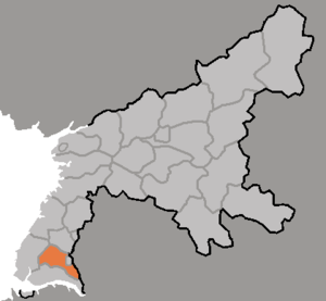
Ryonggang County is a county in South P'yŏngan province, North Korea. It is administered as a part of Namp'o Special City. It is famous for its local apples.
Administrative divisions
Ryonggang-gun is divided into one town (ŭp) and 10 villages (ri):
|
Transportation
Ryonggang County is served by the P'yŏngnam and Ryonggang lines of the Korean State Railway.
See also
External links
 Media related to Ryonggang at Wikimedia Commons
- Map of Nyongbyon, in Korean
| Namp'o | |
|---|---|
| Wards | |
| Counties | |
This North Korea location article is a stub. You can help Misplaced Pages by expanding it. |