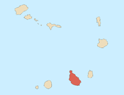
The São Francisco Bay (Portuguese: Baía de São Francisco, also Porto de São Francisco) is a bay on the southeastern coast of the island of Santiago, Cape Verde. It is situated 8 km northeast of the city centre of Praia, the capital of Cape Verde. The bay was mentioned in the 1747 map by Jacques-Nicolas Bellin as "St. Francisco".
References
- Jacques-Nicolas Bellin (1747). "Carte des Isles du Cap Verd = Kaart van de Eilanden van Kabo Verde" (in French).
| City of Praia | ||
|---|---|---|
| Neighbourhoods |   | |
| Geographical features | ||
| Education | ||
| Landmarks | ||
| Culture | ||
| Sports | ||
| Transportation | ||
| Media | ||
| History | ||
| The island of Santiago | ||
|---|---|---|
| Mountains |  | |
| Streams | ||
| Points and promontories | ||
| Other geographic features | ||
| Transportation | ||
| Other topics | ||
14°58′N 23°28′W / 14.97°N 23.46°W / 14.97; -23.46
Categories: