| This article needs additional citations for verification. Please help improve this article by adding citations to reliable sources. Unsourced material may be challenged and removed. Find sources: "Gianh River" – news · newspapers · books · scholar · JSTOR (February 2024) (Learn how and when to remove this message) |
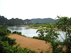
The Gianh River (Vietnamese: Sông Gianh) is a river in the Quảng Bình Province of Vietnam's North Central Coast (Bắc Trung Bộ). The river is 268 kilometres (167 mi) in length.
It was the border between ruling families during the partition of Vietnam following the Trịnh–Nguyễn War of the 17th century, serving to effectively divide the country between northern and southern regions. The 17th parallel used as the border between North Vietnam and South Vietnam from 1954 to 1975 was located just to the south, at the Bến Hải River in Quảng Trị Province.
2009 boat accident
Main article: 2009 Gianh River boat accidentOn 25 January 2009 a boat accident took place on the river, resulting in the deaths of 42 people and the disappearance of five others.
References
- "Police say 40 dead in Vietnamese ferry accident". NBC News. Associated Press. 25 January 2009. Retrieved 9 February 2024.
External links
- Rivers in Quảng Bình Province, from official website of Quảng Bình government
17°45′25″N 106°25′10″E / 17.75694°N 106.41944°E / 17.75694; 106.41944
This article about a location in Quảng Bình province, Vietnam is a stub. You can help Misplaced Pages by expanding it. |
This article related to a river in Vietnam is a stub. You can help Misplaced Pages by expanding it. |