| The examples and perspective in this article deal primarily with the United States and do not represent a worldwide view of the subject. You may improve this article, discuss the issue on the talk page, or create a new article, as appropriate. (April 2020) (Learn how and when to remove this message) |

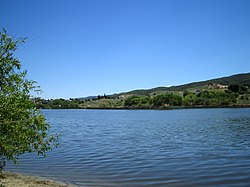
A sag pond is a body of fresh water collected in the lowest parts of a depression formed between two sides of an active strike-slip, transtensional or normal fault zone.
Formation
A sag pond is formed along a strike-slip fault, which may create a depression in the earth. When water enters the depression from rivers, streams, rainfall or snowfall, it fills the low-lying area, and a pond is the result.
Scientific significance
Sag pond formation is common in California, and many of them can be found on the San Andreas Fault, which runs through the western part of the state. Aerial photography or high-resolution topography can easily determine their locations.
Uses
Sag ponds have been converted into stock reservoirs. Larger sag ponds are converted into reservoirs for public water sources, such as San Andreas Lake
Examples
Sag ponds of various sizes can be found along the San Andreas Fault, most notably within the Carrizo Plain and Sierra Pelona Mountains. Some have been converted into reservoirs like the San Andreas Reservoir near San Bruno, California. Various lagoons on the plateau of Pico Island in the Azores are the result of a graben.
Sources
- THE SAG POND STORY – INTERPRETIVE TRAIL GUIDE, retrieved May, 9th 2017
- Nevada-Government Dictionary on Water Words, retrieved April, 3rd 2012
- Simpson, E.L., et al. "An upper cretaceous sag pond deposit: Implications for recognition of local seismicity and surface rupture along the Kaibab monocline, Utah." Geology. Web. Accessed May 9th, 2017.
- Alden, Andrew. "Tectonic Landforms." ThoughtCo. Web. Accessed May 9th, 2017.
- THE SAG POND STORY – INTERPRETIVE TRAIL GUIDE, retrieved May, 9th 2017
- Keiffer, Robert J. 2011. "Ancient sag ponds add to diversity at HREC." Web. Accessed May 9th, 2017.
- Keiffer, Robert J. 2011. "Ancient sag ponds add to diversity at HREC." Web. Accessed May 9th, 2017.
- Alden, Andrew. "Tectonic Landforms." ThoughtCo. Web. Accessed May 9th, 2017.
- DeLong, Stephen B., George E. Hilley, Michael J. Rymer and Carol Prentice. "Fault zone structure from topography: Signatures of en echelon fault slip at Mustang Ridge on the San Andreas Fault, Monterey County, California." 2010. Tectonics, Vol. 29. Web. Accessed May 9th, 2017.
- DeLong, Stephen B., George E. Hilley, Michael J. Rymer and Carol Prentice. "Fault zone structure from topography: Signatures of en echelon fault slip at Mustang Ridge on the San Andreas Fault, Monterey County, California." 2010. Tectonics, Vol. 29. Web. Accessed May 9th, 2017.
- THE SAG POND STORY – INTERPRETIVE TRAIL GUIDE, retrieved May, 9th 2017
- MobileRanger. Web. Accessed May 9th, 2017.
- "Ilha do Pico" (in Portuguese). Enciclopédia Açoriana. Retrieved 10 July 2021.
