| This article needs additional citations for verification. Please help improve this article by adding citations to reliable sources. Unsourced material may be challenged and removed. Find sources: "Sagter Ems" – news · newspapers · books · scholar · JSTOR (August 2024) (Learn how and when to remove this message) |
You can help expand this article with text translated from the corresponding article in German. (September 2011) Click for important translation instructions.
|
| Sagter Ems | |
|---|---|
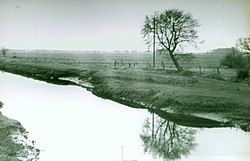
 The Sagter Ems in 1931 The Sagter Ems in 1931 | |
| Location | |
| Country | Germany |
| State | Lower Saxony |
| Physical characteristics | |
| Mouth | |
| • location | Leda |
| • coordinates | 53°10′40″N 7°40′18″E / 53.1778°N 7.6718°E / 53.1778; 7.6718 |
| Basin features | |
| Progression | Leda→ Ems→ North Sea |
Sagter Ems is a river of Lower Saxony, Germany. It is formed at the confluence of the rivers Ohe and Marka west of Friesoythe. It is 28 km long. At its confluence with the Dreyschloot (a branch of the Soeste), the river Leda is formed. The Sagter Ems is known as the Leda in East Frisia.
The Sagter Ems is affected by the tide along the portion of its course up to Strücklingen.
See also
References
- "Gewässer Nr. 5 | Gewässerbeschreibung". Fischereiverein-Stickhausen e.V. Retrieved 9 August 2024.
- "Törn: East Frisia inland - Frisian freedom: East Frisia by boat". BOOTE Das Motorboote Magazin. Retrieved 9 August 2024.
This article related to a river in Lower Saxony is a stub. You can help Misplaced Pages by expanding it. |