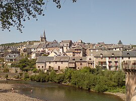
Commune in Occitanie, France
You can help expand this article with text translated from the corresponding article in French. (December 2008) Click for important translation instructions.
|
| Saint-Côme-d'Olt | |
|---|---|
| Commune | |
 A view of Saint-Côme-d'Olt from the bridge A view of Saint-Côme-d'Olt from the bridge | |
 Coat of arms Coat of arms | |
| Location of Saint-Côme-d'Olt | |
  | |
| Coordinates: 44°30′59″N 2°48′55″E / 44.5164°N 2.8153°E / 44.5164; 2.8153 | |
| Country | France |
| Region | Occitania |
| Department | Aveyron |
| Arrondissement | Rodez |
| Canton | Lot et Palanges |
| Government | |
| • Mayor (2020–2026) | Bernard Scheuer |
| Area | 30.1 km (11.6 sq mi) |
| Population | 1,446 |
| • Density | 48/km (120/sq mi) |
| Time zone | UTC+01:00 (CET) |
| • Summer (DST) | UTC+02:00 (CEST) |
| INSEE/Postal code | 12216 /12500 |
| Elevation | 340–840 m (1,120–2,760 ft) (avg. 340 m or 1,120 ft) |
| French Land Register data, which excludes lakes, ponds, glaciers > 1 km (0.386 sq mi or 247 acres) and river estuaries. | |
Saint-Côme-d'Olt (French pronunciation: [sɛ̃ kom dɔlt], literally Saint-Côme of Olt; Occitan: Sant Cosme) is a commune in the Aveyron department in southern France. It is one of the Les Plus Beaux Villages de France (most beautiful villages of France).
Geography
The commune is located in the Lot valley, near the confluence with the river called Boralde of Saint-Chély-d'Aubrac.
Way of St. James
Saint-Côme-d'Olt with its twisted church spire is located on the Le Puy route (Latin: Via Podiensis, French: route du Puy) of the Way of St. James.
Pilgrims come from Saint-Chély-d'Aubrac. Their next stage is Espalion, and its church of Perse.
Population
| Year | Pop. | ±% |
|---|---|---|
| 1962 | 949 | — |
| 1968 | 1,003 | +5.7% |
| 1975 | 1,103 | +10.0% |
| 1982 | 1,207 | +9.4% |
| 1990 | 1,198 | −0.7% |
| 1999 | 1,257 | +4.9% |
| 2008 | 1,387 | +10.3% |
Administration
| Term | Mayor | Party |
|---|---|---|
| March 2001 to March 2008 | Louis Morvan | P.S |
| March 2008 to 2014 | Nathalie Auguy-Périé | U.M.P |
| March 2014 to 2020 and 2020-- | Bernard Scheuer |
See also
References
- "Répertoire national des élus: les maires" (in French). data.gouv.fr, Plateforme ouverte des données publiques françaises. 13 September 2022.
- "Populations de référence 2022" (in French). The National Institute of Statistics and Economic Studies. 19 December 2024.
This Aveyron geographical article is a stub. You can help Misplaced Pages by expanding it. |