| Saint-Sauveur-Lendelin | |
|---|---|
| Part of Saint-Sauveur-Villages | |
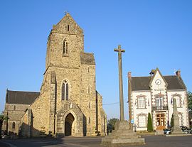
 The church of Saint-Laurent, the 1571 cross and the town hall The church of Saint-Laurent, the 1571 cross and the town hall | |
| Location of Saint-Sauveur-Lendelin | |
  | |
| Coordinates: 49°07′52″N 1°24′44″W / 49.1311°N 1.4122°W / 49.1311; -1.4122 | |
| Country | France |
| Region | Normandy |
| Department | Manche |
| Arrondissement | Coutances |
| Canton | Agon-Coutainville |
| Commune | Saint-Sauveur-Villages |
| Area | 16.39 km (6.33 sq mi) |
| Population | 1,748 |
| • Density | 110/km (280/sq mi) |
| Time zone | UTC+01:00 (CET) |
| • Summer (DST) | UTC+02:00 (CEST) |
| Postal code | 50490 |
| Elevation | 23–123 m (75–404 ft) (avg. 65 m or 213 ft) |
| French Land Register data, which excludes lakes, ponds, glaciers > 1 km (0.386 sq mi or 247 acres) and river estuaries. | |
Saint-Sauveur-Lendelin (French pronunciation: [sɛ̃ sovœʁ lɑ̃dlɛ̃]) is a former commune in the Manche department in Normandy in north-western France. On 1 January 2019, it was merged into the new commune Saint-Sauveur-Villages.
See also
References
- Téléchargement du fichier d'ensemble des populations légales en 2019, INSEE
- Des villages de Cassini aux communes d'aujourd'hui: Commune data sheet Saint-Sauveur-Lendelin, EHESS (in French).
- Arrêté préfectoral 26 December 2018 (in French)
This Manche geographical article is a stub. You can help Misplaced Pages by expanding it. |