You can help expand this article with text translated from the corresponding article in Spanish. (August 2011) Click for important translation instructions.
|
| Salinillas de Buradon/Buradon Gatzaga | |
|---|---|
| Concejo | |
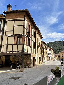
 View of Salinillas de Buradón, with its medieval walls visible View of Salinillas de Buradón, with its medieval walls visible | |
 Coat of arms Coat of arms | |
   | |
| Coordinates: 42°38′N 2°50′W / 42.63°N 2.83°W / 42.63; -2.83 | |
| Country | Spain |
| Autonomous community | Basque Country |
| Province | Álava |
| Comarca | Rioja Alavesa |
| Municipality | Labastida |
| Founded | 1264 (1264) |
| Area | |
| • Total | 11.25 km (4.34 sq mi) |
| Elevation | 504 m (1,654 ft) |
| Population | |
| • Total | 119 |
| • Density | 11/km (27/sq mi) |
| Postal code | 01212 |
Salinillas de Buradón (Spanish pronunciation: [saliˈniʝas ðe βuɾaˈðon]) or Gatzaga Buradon (Basque pronunciation: [gats̻aɣa βuɾaðon]) is a village and concejo located in the municipality of Labastida, in Álava province, Basque Country, Spain. It was an independent municipality until 1974, when it was absorbed into Labastida.

It is noteworthy for its well-preserved medieval walls and historic town centre, and its location sheltered between hills overlooking the River Ebro.
References
- "Nomenclátor: Núcleos". Entidades Locales de Álava (in Spanish). Diputación Foral de Álava. 1 January 2021. Retrieved 3 November 2023.
- "Variaciones de los municipios de España desde 1842" (PDF) (in Spanish). Ministry of Public Administrations. October 2008. p. 11. Archived from the original (PDF) on 5 April 2018. Retrieved 13 November 2023.
- Ortega, Hektor (25 August 2021). "Buradón. Salinas a pie de muralla". Noticias de Álava (in Spanish). Retrieved 3 November 2023.
External links
 Media related to Buradon Gatzaga/Salinillas de Buradón at Wikimedia Commons
This article about a location in the Basque Country, Spain, is a stub. You can help Misplaced Pages by expanding it. |