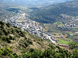
| Sallama
סלאמה سلامة | |
|---|---|
 | |
  | |
| Coordinates: 32°53′40″N 35°22′14″E / 32.89444°N 35.37056°E / 32.89444; 35.37056 | |
| Grid position | 185/254 PAL |
| Country | |
| District | Northern |
| Council | Misgav |
| Population | 3,552 |
Sallama (Arabic: سلامة; Hebrew: סלאמה) is a Bedouin village in northern Israel. Located in the Galilee near the Tzalmon Stream, it falls under the jurisdiction of Misgav Regional Council. In 2022 its population was 3,552. The village was recognized by the state in 1976.
History
Sallama has been identified as the site of the village of Selamin (Salmon or Tselamon) in the Roman Province of Galilee.
At some point between 1688 and 1692, the Zayadina family, who not long before moved to the nearby village of Arraba, had assaulted and destroyed Sallama, whose Druze sheikh controlled the Shaghur subdistrict to which both villages belonged. The Druze subsequently fled Sallama and at least eight other villages in the subdistrict, including Kammaneh and Dallata. At least some of these Druze migrated to the Hauran to join their co-religionists. The Zayadina meanwhile began their influence in the Galilee and gained the tax farm of Shaghur.
In 1875, on the top of the site Guérin found the remains of a rectangular enclosure, 80 paces by 50. Within the enclosure and along the walls have been built twenty crude vaulted chambers, which appeared to him modern. Besides the cisterns and caves mentioned by Lieutenant Kitchener, Guerin observed two presses cut in the rock. In 1881, the PEF's Survey of Western Palestine noted the presence of "Heaps of stones, cisterns, and caves" in the village site.
See also
References
- ^ "Regional Statistics". Israel Central Bureau of Statistics. Retrieved 21 March 2024.
- Palmer refers to the site, in his day a ruin, by the name of "Khŭrbet Sellâmeh," meaning the Ruin of Sellameh. See Palmer, 1881, p. 130
- Tsafrir, 1994, p225.
- Mishna Yerushalmi Kil'ayim 4,6; Mishna Kil'ayim 4,9; Josephus War II,573: Σελαμίν or Σελλαμίν
- ^ Firro 1997, pp. 45–46.
- Guérin, 1880, pp. 460-462; as given in Conder and Kitchener, 1881, SWP I, p. 405
- Conder and Kitchener, 1881, SWP I, p. 405
Bibliography
- Conder, C.R.; Kitchener, H.H. (1881). The Survey of Western Palestine: Memoirs of the Topography, Orography, Hydrography, and Archaeology. Vol. 1. London: Committee of the Palestine Exploration Fund.
- Firro, Kais (1992). A History of the Druzes. Vol. 1. Brill. ISBN 90-04-09437-7.
- Guérin, V. (1880). Description Géographique Historique et Archéologique de la Palestine (in French). Vol. 3: Galilee, pt. 1. Paris: L'Imprimerie Nationale.
- Palmer, E.H. (1881). The Survey of Western Palestine: Arabic and English Name Lists Collected During the Survey by Lieutenants Conder and Kitchener, R. E. Transliterated and Explained by E.H. Palmer. Committee of the Palestine Exploration Fund.
- Tsafrir, Y.; Leah Di Segni; Judith Green (1994). (TIR): Tabula Imperii Romani: Judaea, Palaestina. Jerusalem: Israel Academy of Sciences and Humanities. ISBN 965-208-107-8.
External links
- Survey of Western Palestine, Map 6: IAA, Wikimedia commons
| Misgav Regional Council | |
|---|---|
| Kibbutzim | |
| Moshavim | |
| Community settlements | |
| Bedouin villages | |