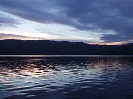
| Samnangerfjorden | |
|---|---|
 View of the fjord View of the fjord | |
  | |
| Location | Vestland county, Norway |
| Coordinates | 60°20′20″N 5°39′17″E / 60.3388°N 5.6547°E / 60.3388; 5.6547 |
| Primary outflows | Fusafjorden |
| Basin countries | Norway |
| Max. length | 22 kilometres (14 mi) |
Samnangerfjorden (Urban East Norwegian: [ˈsɑ̂mnɑŋərˌfjuːɳ]) is a fjord in Vestland county, Norway. The 22-kilometre (14 mi) long fjord is located in the municipalities of Bjørnafjorden and Samnanger. The head of the fjord is located in Samnanger, surrounded by the villages of Årland, Haga, and Tysse. The fjord flows to the southwest from there and eventually flows into the Fusafjorden (which later joins the large Bjørnafjorden). The fjord forms the southern boundary of the Bergen Peninsula.
See also
References
- Evensen, Knut Harald, ed. (2006). NAF Veibok 2007-2009 (in Norwegian) (28 ed.). Oslo: Norges Automobil-Forbund. p. 33.
- "Samnangerfjorden" (in Norwegian). yr.no. Retrieved 12 July 2014.
This Vestland location article is a stub. You can help Misplaced Pages by expanding it. |