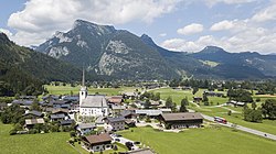
| St. Martin bei Lofer | |
|---|---|
| Municipality | |
 | |
 Coat of arms Coat of arms | |
 | |
| Coordinates: 47°34′00″N 12°42′00″E / 47.56667°N 12.70000°E / 47.56667; 12.70000 | |
| Country | Austria |
| State | Salzburg |
| District | Zell am See |
| Government | |
| • Mayor | Josef Leitinger (ÖVP) |
| Area | |
| • Total | 63.55 km (24.54 sq mi) |
| Elevation | 633 m (2,077 ft) |
| Population | |
| • Total | 1,153 |
| • Density | 18/km (47/sq mi) |
| Time zone | UTC+1 (CET) |
| • Summer (DST) | UTC+2 (CEST) |
| Postal code | 5092 |
| Area code | 06588 |
| Vehicle registration | ZE |
| Website | www.stmartin.at |
St. Martin bei Lofer is a municipality in the district of Zell am See (Pinzgau region), in the state of Salzburg in Austria.
Geography
The municipality lies in the Loferer Land in the Pinzgauer Saalach valley.
Lamprechtsofen (deepest cave in the nation) is located near the village Obsthurn.
References
- "Dauersiedlungsraum der Gemeinden Politischen Bezirke und Bundesländer - Gebietsstand 1.1.2018". Statistics Austria. Retrieved 10 March 2019.
- "Einwohnerzahl 1.1.2018 nach Gemeinden mit Status, Gebietsstand 1.1.2018". Statistics Austria. Retrieved 9 March 2019.
External links
This Salzburg state location article is a stub. You can help Misplaced Pages by expanding it. |