| Santo Domingo de los Colorados | |
|---|---|
| Canton | |
 | |
| Coordinates: 00°15′S 079°09′W / 0.250°S 79.150°W / -0.250; -79.150 | |
| Country | |
| Province | Santo Domingo de los Tsáchilas |
| Established | July 3, 1967 |
| Area | |
| • Total | 3,454 km (1,334 sq mi) |
| Population | |
| • Total | 441,583 |
| • Density | 130/km (330/sq mi) |
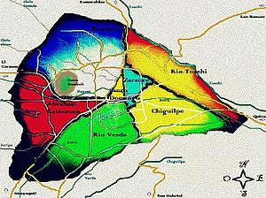
Santo Domingo de los Colorados or simply known as Santo Domingo, is the biggest canton in the Santo Domingo de los Tsáchilas Province, after La Concordia officially became part of the province on May 31, 2013. The canton is named after its seat, the town of Santo Domingo. The canton partially occupies the Toachi river basin. The Toachi river flows into the Daule river.
Demographics
Ethnic groups as of the Ecuadorian census of 2010:
- Mestizo 81.0%
- Afro-Ecuadorian 7.7%
- White 6.8%
- Montubio 2.5%
- Indigenous 1.7%
- Other 0.3%
Political divisions

Santo Domingo Canton is divided into 7 urban parishes and 7 rural parishes.
- Urban parishes: Santo Domingo, Chiguilpe, Río Verde, Bombolí, Zaracay, Abraham Calazacón, Río Toachi
- Rural parishes: San José de Alluriquín, El Esfuerzo, Luz de América, Puerto Limón, San Jacinto del Búa, Santa María del Toachi, Valle Hermoso
Climate
| Climate data for Santo Domingo, elevation 660 m (2,170 ft), (1971–2000) | |||||||||||||
|---|---|---|---|---|---|---|---|---|---|---|---|---|---|
| Month | Jan | Feb | Mar | Apr | May | Jun | Jul | Aug | Sep | Oct | Nov | Dec | Year |
| Mean daily maximum °C (°F) | 26.2 (79.2) |
27.0 (80.6) |
27.8 (82.0) |
27.7 (81.9) |
27.0 (80.6) |
26.1 (79.0) |
25.9 (78.6) |
26.0 (78.8) |
25.9 (78.6) |
25.4 (77.7) |
25.2 (77.4) |
25.3 (77.5) |
26.3 (79.3) |
| Mean daily minimum °C (°F) | 18.9 (66.0) |
19.1 (66.4) |
19.4 (66.9) |
19.3 (66.7) |
19.3 (66.7) |
18.8 (65.8) |
18.1 (64.6) |
18.0 (64.4) |
18.2 (64.8) |
18.3 (64.9) |
18.1 (64.6) |
18.6 (65.5) |
18.7 (65.6) |
| Average precipitation mm (inches) | 525.0 (20.67) |
495.0 (19.49) |
559.0 (22.01) |
538.0 (21.18) |
323.0 (12.72) |
177.0 (6.97) |
86.0 (3.39) |
61.0 (2.40) |
102.0 (4.02) |
85.0 (3.35) |
80.0 (3.15) |
196.0 (7.72) |
3,227 (127.07) |
| Average relative humidity (%) | 91 | 90 | 90 | 90 | 90 | 92 | 91 | 91 | 91 | 91 | 91 | 91 | 91 |
| Source: FAO | |||||||||||||
| Climate data for Chiriboga, elevation 1,680 m (5,510 ft), (1961–1990) | |||||||||||||
|---|---|---|---|---|---|---|---|---|---|---|---|---|---|
| Month | Jan | Feb | Mar | Apr | May | Jun | Jul | Aug | Sep | Oct | Nov | Dec | Year |
| Mean daily maximum °C (°F) | 20.7 (69.3) |
20.7 (69.3) |
20.8 (69.4) |
21.1 (70.0) |
21.7 (71.1) |
21.3 (70.3) |
21.7 (71.1) |
21.7 (71.1) |
22.2 (72.0) |
21.7 (71.1) |
22.2 (72.0) |
21.5 (70.7) |
21.4 (70.6) |
| Daily mean °C (°F) | 16.2 (61.2) |
16.2 (61.2) |
16.3 (61.3) |
16.5 (61.7) |
16.5 (61.7) |
16.1 (61.0) |
15.8 (60.4) |
15.8 (60.4) |
16.1 (61.0) |
16.2 (61.2) |
16.2 (61.2) |
16.2 (61.2) |
16.2 (61.1) |
| Mean daily minimum °C (°F) | 11.6 (52.9) |
11.6 (52.9) |
11.6 (52.9) |
11.0 (51.8) |
10.8 (51.4) |
10.0 (50.0) |
9.1 (48.4) |
9.0 (48.2) |
9.8 (49.6) |
10.6 (51.1) |
10.3 (50.5) |
11.0 (51.8) |
10.5 (51.0) |
| Average precipitation mm (inches) | 301.0 (11.85) |
337.0 (13.27) |
407.0 (16.02) |
363.0 (14.29) |
227.0 (8.94) |
129.0 (5.08) |
46.0 (1.81) |
52.0 (2.05) |
99.0 (3.90) |
107.0 (4.21) |
93.0 (3.66) |
170.0 (6.69) |
2,331 (91.77) |
| Source: FAO | |||||||||||||
References
- Santo Domingo de los Colorados, Cantón at GEOnet Names Server
- Citypopulation.de Population and area of Santo Domingo Canton
- Santo Domingo de los Colorados at www.santodomingo.gob.ec
- Santo Domingo de los Tsáchilas Archived 2010-07-24 at the Wayback Machine at www.gptsachila.gob.ec
- "Cantones y Parroquias - Prefectura de Santo Domingo de los Tsáchilas". www.gptsachila.gob.ec. Retrieved 2015-12-30.
- "Resultados".
- "CLIMWAT climatic database". Food and Agriculture Organization of United Nations. Retrieved 20 June 2024.
- "World-wide Agroclimatic Data of FAO (FAOCLIM)". Food and Agriculture Organization of United Nations. Retrieved 23 June 2024.
This Ecuador location article is a stub. You can help Misplaced Pages by expanding it. |