| This article relies largely or entirely on a single source. Relevant discussion may be found on the talk page. Please help improve this article by introducing citations to additional sources. Find sources: "Sauer" Rhine – news · newspapers · books · scholar · JSTOR (December 2021) |
| Sauer | |
|---|---|
 | |
  | |
| Location | |
| Countries | Germany and France |
| Physical characteristics | |
| Source | |
| • location | Palatine Forest |
| Mouth | |
| • location | Rhine |
| • coordinates | 48°54′55″N 8°9′25″E / 48.91528°N 8.15694°E / 48.91528; 8.15694 |
| Length | ~85 km (53 mi) |
| Basin features | |
| Progression | Rhine→ North Sea |
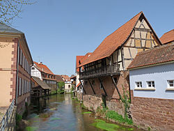
The Sauer is a river in France (Alsace) and Germany (Rhineland-Palatinate). A left tributary of the river Rhine, its total length is about 85 kilometres (53 mi), of which 64 km (40 mi) in France. Its upper course, in Germany, is called Saarbach. Its source is in the Palatinate forest, near the French border, south of Pirmasens. It flows into France near Schœnau, and continues through Wœrth and north of Haguenau. It flows into the Rhine in Seltz, opposite the mouth of the Murg.
Tributaries
References
| Baltic Sea | |
|---|---|
| Black Sea | |
| North Sea | |
| Maas | |
This article related to a river in France is a stub. You can help Misplaced Pages by expanding it. |
This article related to a river in Rhineland-Palatinate is a stub. You can help Misplaced Pages by expanding it. |
