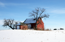
Unincorporated community in Indiana, United States
| Sedalia | |
|---|---|
| Unincorporated community | |
 Grain elevator in Sedalia Grain elevator in Sedalia | |
 | |
| Coordinates: 40°24′56″N 86°30′53″W / 40.41556°N 86.51472°W / 40.41556; -86.51472 | |
| Country | United States |
| State | Indiana |
| County | Clinton |
| Township | Owen |
| Elevation | 781 ft (238 m) |
| ZIP code | 46067 |
| FIPS code | 18-68598 |
| GNIS feature ID | 443192 |
Sedalia is an unincorporated community in Owen Township, Clinton County, Indiana, United States.
History
Sedalia was platted March 31, 1873 by James A. Campbell and Jackson B. McCune and was named after Sedalia, Illinois, the home town of an official of the Vandalia Railroad. McCune built the first house and was the first postmaster. William Miller operated the first store, Allen Branch was the first blacksmith, and Dr. Keeny the first physician.
Geography
Sedalia is located along State Road 26, half a mile east of State Road 75.
Gallery
References
- ^ U.S. Geological Survey Geographic Names Information System: Sedalia, Indiana
- "U.S. Census website". United States Census Bureau. Retrieved January 31, 2008.
- Claybaugh, Joseph (1913). "Owen Township". History of Clinton County, Indiana. Indianapolis: A. W. Bowen & Company.
External links
 Media related to Sedalia, Indiana at Wikimedia Commons
| Municipalities and communities of Clinton County, Indiana, United States | ||
|---|---|---|
| County seat: Frankfort | ||
| City | ||
| Towns | ||
| Townships | ||
| CDPs | ||
| Other communities | ||
This Clinton County, Indiana location article is a stub. You can help Misplaced Pages by expanding it. |

