| This article needs additional citations for verification. Please help improve this article by adding citations to reliable sources. Unsourced material may be challenged and removed. Find sources: "Seri Kembangan" – news · newspapers · books · scholar · JSTOR (June 2011) (Learn how and when to remove this message) |
Town in Selangor, Malaysia
| Seri Kembangan | |
|---|---|
| Town | |
      | |
  | |
| Coordinates: 3°00′57″N 101°42′02″E / 3.01583°N 101.70056°E / 3.01583; 101.70056 | |
| Country | |
| State | |
| District | Petaling |
| Government | |
| • Subang Jaya Municipal Council President | Dato' Nor Hisham Ahmad Dahlan |
| • Member of Parliament | Y.B. Yeo Bee Yin (DAP) - Puchong |
| • Assemblyman | Y.B Ean Yong Hian Wah (DAP) - Seri Kembangan |
| Time zone | UTC8 (MST) |
| ZIP Code | 43300 |
| Area code | +6-03-89 |
| Seri Kembangan | |||||||
|---|---|---|---|---|---|---|---|
| Chinese | 史里肯邦安 | ||||||
| |||||||
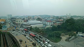
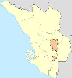
Seri Kembangan, also known as Serdang, formerly known as Serdang New Village, is a town located in Petaling District, Selangor, Malaysia. It is located in between Kuala Lumpur and Putrajaya. The town is now a considerable city in size. It is located near the northern end of the PLUS Expressway Southern Route ![]() North–South Expressway Southern Route.
North–South Expressway Southern Route.
History
Seri Kembangan was established as the Serdang New Village in 1950 when the British moved Malaysian Chinese villagers living around Sungai Besi to a centralised location due to the Communist threat during the Malayan Emergency as part of the Briggs Plan.
In its early days, the village had 50 houses and all were built from scratch because the British only provided empty plots of land. The area was close to rubber estates and the jungle posed dangers of a different kind. Most of the 15,000 inhabitants earned meagre incomes as mining workers and rubber tappers.
At one point, the Seri Kembangan New Village was known for cottage industries like shoe-making and type settings services but this has been overtaken by more profitable ventures.
There are now 2,500 houses with only a smattering of the original wooden houses left and the population is estimated to be 150,000, largely made up of entrepreneurs, businessmen, professionals, government servants who are working in Putrajaya and other multinational corporations employees located in Cyberjaya.
The only form of entertainment around the vicinity in the 1950s until the 1970s was a cinema.
After the 1998 Commonwealth Games, more developments took place from 2000 onwards and other prominent developments includes AEON Equine Park, McDonald's, Pasar Borong Selangor (wholesale market), Maybank, Giant Hypermarket and other businesses transformed this area into a business hub.
Climate and weather
Protected by the Titiwangsa Mountains in the east and Indonesia's Sumatra Island in the west, Seri Kembangan has a tropical rainforest climate (Köppen climate classification Af) which is warm and sunny, along with abundant rainfall, especially during the northeast monsoon season from October to March. Temperatures tend to remain constant. Maximums hover between 31 and 33 °C (88 and 91 °F) and have never exceeded 39.3 °C (102.7 °F), while minimums hover between 22 and 23.5 °C (71.6 and 74.3 °F) and have never fallen below 14.4 °C (57.9 °F). Seri Kembangan typically receives minimum 2,600 mm (100 in) of rain annually; June and July are relatively dry, but even then rainfall typically exceeds 133 millimetres (5.2 in) per month.
| Climate data for Subang Jaya (Approximation 5 km distance from Seri Kembangan) | |||||||||||||
|---|---|---|---|---|---|---|---|---|---|---|---|---|---|
| Month | Jan | Feb | Mar | Apr | May | Jun | Jul | Aug | Sep | Oct | Nov | Dec | Year |
| Record high °C (°F) | 36 (97) |
37 (99) |
37 (99) |
36 (97) |
36 (97) |
36 (97) |
36 (97) |
36 (97) |
35 (95) |
35 (95) |
35 (95) |
35 (95) |
37 (99) |
| Mean daily maximum °C (°F) | 32.1 (89.8) |
32.9 (91.2) |
33.2 (91.8) |
33.1 (91.6) |
32.9 (91.2) |
32.7 (90.9) |
32.3 (90.1) |
32.3 (90.1) |
32.1 (89.8) |
32.1 (89.8) |
31.6 (88.9) |
31.5 (88.7) |
32.4 (90.3) |
| Mean daily minimum °C (°F) | 22.5 (72.5) |
22.8 (73.0) |
23.2 (73.8) |
23.7 (74.7) |
23.9 (75.0) |
23.6 (74.5) |
23.2 (73.8) |
23.1 (73.6) |
23.2 (73.8) |
23.2 (73.8) |
23.2 (73.8) |
22.9 (73.2) |
23.2 (73.8) |
| Record low °C (°F) | 18 (64) |
20 (68) |
20 (68) |
21 (70) |
21 (70) |
20 (68) |
19 (66) |
20 (68) |
20 (68) |
21 (70) |
21 (70) |
19 (66) |
18 (64) |
| Average rainfall mm (inches) | 192 (7.6) |
181 (7.1) |
251 (9.9) |
292 (11.5) |
191 (7.5) |
133 (5.2) |
136 (5.4) |
155 (6.1) |
197 (7.8) |
258.5 (10.18) |
297 (11.7) |
246.9 (9.72) |
2,530.4 (99.62) |
| Average rainy days (≥ 1.0 mm) | 11 | 12 | 14 | 16 | 13 | 9 | 10 | 11 | 13 | 16 | 18 | 15 | 158 |
| Mean monthly sunshine hours | 186.0 | 194.9 | 207.7 | 198.0 | 207.7 | 195.0 | 201.5 | 189.1 | 165.0 | 170.5 | 153.0 | 161.2 | 2,229.6 |
| Source 1: Jabatan Meteorologi Malaysia – Subang 1961–2010 | |||||||||||||
| Source 2: World Meteorological Organisation (UN, 1971–2000) — Source #3: Hong Kong Observatory (sun only, 1961–1990) | |||||||||||||
Politics
The early Community leaders of the village since 1952 who had greatly contributed towards the development of Serdang New Village were Mr Hee Kon Swee, JP, PPN and Mr Chow Pak Fah, PJK, PPM. Various Government dignitaries were invited by them to assist in improving the conditions and developing the infrastructure of the village. In 1964, the first Prime Minister, Tunku Abdul Rahman visited the village to have the first hand knowledge about the village. This was followed by Assistant Education Minister, Mr Lee Siok Yew. On 12 November 1968, Deputy Prime Minister Tun Abdul Razak came to open ceremony of the Serdang New Village Secondary School. In 1969, Deputy Prime Minister, Tun Abdul Razak came again for the groundbreaking of Serdang New Village Clinic. On 10 March 1972, Minister of Health, Mr Lee Siok Yew and Minister of Finance, Tun Tan Siew Sin visited the village. The village also saw the visit of the Chief Minister of Selangor, Dato Harun Idris. These two pioneers Mr Hee and Mr Chow never thought their efforts in improving the lives of the village residents would one day turn this backwater village to become a bustling city today.
At the national level, Seri Kembangan is part of the Puchong parliamentary constituency, currently represented by Yeo Bee Yin from DAP. Meanwhile, Seri Kembangan forms its own constituency in the Selangor State Legislative Assembly. The incumbent assemblyperson is Wong Siew Ki, also from DAP. Earlier in 1959 till 1964, it was known as Damansara Constituency before it was called Serdang and later Puchong Constituency. The first MP was Karam Singh Veriah from Socialist Front and won the Damansara Constituency twice.
Demographics
As of 2020, Seri Kembangan has a population of 130,252 residents. Most of the population are Chinese followed by Malays, Indians and others.
| |||||||||||||||||||||||||||||||||||
Leisure
Shopping

Seri Kembangan has three major malls: the aforementioned The Mines Shopping Mall, an AEON store in Taman Equine, Giant Hypermarket, and South City Plaza.
Food

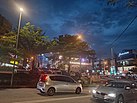
Seri Kembangan is known for its good and varied street food, incorporating Chinese, Malay, Indian and other races' influences into its literal melting pot. The best places to savour street cuisine include Seri Kembangan Night Market and Seri Serdang Night Market (opens every Monday and Friday nights). The more prominent local dishes include nasi lemak, asam laksa, char kway teow, curry noodle, mamak fried mee, rojak and cendol.
Tourism
Seri Kembangan is home to the Mines Wellness City, a healthcare-oriented resort city. There used to be a theme park known as Mines Wonderland, which operated between 1997 and 2011.
Transportation
Car
Seri Kembangan is located at the intersection of three tolled highways - ![]() North–South Expressway Southern Route,
North–South Expressway Southern Route, ![]() Sungai Besi Expressway and
Sungai Besi Expressway and ![]() East–West Link Expressway. The
East–West Link Expressway. The ![]() Damansara–Puchong Expressway,
Damansara–Puchong Expressway, ![]() Maju Expressway and
Maju Expressway and ![]() South Klang Valley Expressway runs near the western fringe of this township. The interchange with
South Klang Valley Expressway runs near the western fringe of this township. The interchange with ![]() Shah Alam Expressway,
Shah Alam Expressway, ![]() Kajang Dispersal Link Expressway,
Kajang Dispersal Link Expressway, ![]() Sungai Besi–Ulu Klang Elevated Expressway, MRR2 and Federal Route 28 lies nearby.
Sungai Besi–Ulu Klang Elevated Expressway, MRR2 and Federal Route 28 lies nearby.
Consequently, Seri Kembangan is regarded as the southern gateway into Kuala Lumpur for motorists travelling from southern Selangor, Negeri Sembilan, Malacca or Johor.
Public transportation
The main rail station serving Seri Kembangan is KB05 KTM Serdang, part of the KTM Komuter network operated by state railway operator KTMB.
The 12MRT Putrajaya line Phase 2 project that was completed and opened on March 16, 2023 features six stations that are located in Seri Kembangan which are PY31 Serdang Raya Utara, PY32 Serdang Raya Selatan, PY33 Serdang Jaya, PY34 UPM, PY36 Taman Equine and PY37 Putra Permai.
Alternately there is the SP16 PY29 Sungai Besi MRT station which is about 4 km north.
Education
- Universiti Putra Malaysia
- PORTMAN College
- SK Taman Universiti
- SK Seri Serdang
- SK Serdang
- SK Desaminium
- SK Taman Sungai Besi Indah
- Sekolah Menengah Universal Hua Xia
- S.J.K.(C) Bukit Serdang
- S.J.K.(C) Serdang Baru 1
- S.J.K.(C) Serdang Baru 2
- S.J.K.(C) Kung Man
- S.J.K.(T) Serdang
- SMK Seri Serdang
- SMK Seri Indah
- SMK Seri Kembangan
- SMK Desaminium
- SMK Bandar Puncak Jalil
- Hua Xia International School
- Kingsgate International School
- Alice Smith School, Secondary Campus (International & Private School)
- Australian International School Malaysia - located in MINES Resort City.
- Rafflesia International & Private School
Notable people
- Aidil Aziz (born 1987), actor
References
- "Climatological Information for Kuala Lumpur, Malaysia". Hong Kong Observatory. Retrieved 2010-10-28.
- "Malaysia: Klang Valley MRT Putrajaya Line Opens in Kuala Lumpur". Kuala Lumpur. March 16, 2023. Retrieved March 20, 2023.
- "Contact Map Archived 2015-09-23 at the Wayback Machine." Australian International School, Malaysia. Retrieved on 23 September 2015. "Australian International School Malaysia 22 Jalan Anggerik, The MINES Resort City, 43300 Seri Kembangan, Selangor Darul Ehsan, Malaysia"
| State of Selangor | |||||||||||||||
|---|---|---|---|---|---|---|---|---|---|---|---|---|---|---|---|
| |||||||||||||||
| General topics |
|  | |||||||||||||
| Administrative divisions |
| ||||||||||||||
| City councils (Majlis Bandaraya) |
| ||||||||||||||
| Municipal councils (Majlis Perbandaran) |
| ||||||||||||||
| District councils (Majlis Daerah) |
| ||||||||||||||
3°02′N 101°43′E / 3.033°N 101.717°E / 3.033; 101.717
Categories: